Deliktaş geodata
Deliktaş (Sivas) is a seat of a third-order administrative division; located in Turkey in Europe/Istanbul (GMT+3) time zone. In our database, there are 1323 cities with bigger population. Compared to other cities in Turkey, 59.3% of cities are located further ↓South; 57.5% of cities are located further ←West and 97.4% of cities have lower elevation than Deliktaş. Note1


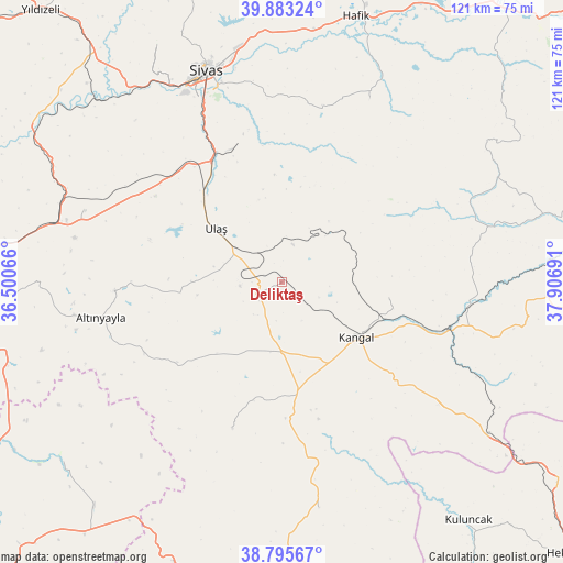
Deliktaş GPS coordinates[2]
39° 20' 29.652" North, 37° 12' 13.608" East
| Map corner | latitude | longitude |
|---|---|---|
| Upper-left | 39.88324°, | 36.50066° |
| Center: | 39.34157°, | 37.20378° |
| Lower-right: | 38.79567°, | 37.90691° |
| Map W x H: | 120.9×120.9 km | = 75.1×75.1mi |
| max Lat: | 42.02683° ⇑40.7% North |
| Deliktaş: | 39.34157° |
| min Lat: | ⇓59.3% South 35.9025° |
| min Long | Deliktaş | max Long |
| 25.90902° | 37.20378° | 44.60099° |
| W 57.5%⇐ | ⇒42.5% E |
Elevation
Elevation of Deliktaş is 1812 m = 5945 ft, and this is 1094.6 m = 3591 ft above average elevation for this country.
| Max E: |
2682 m = 8799 ft | 2.6% |
| Deliktaş | 1812 m 5945 ft | |
| Avg. | 717.4 m = 2354 ft | |
Min E: |
0 m = 0 ft | 97.4% |
See also: Turkey elevation on elevation.city.
Geographical zone
Deliktaş is located in North temperate zone (between Tropic of Cancer and the Arctic Circle). Distance of this Northern Tropic circle is 1768.5 km =1098.9 mi to South.| Distance of | km | miles | from Deliktaş |
|---|---|---|---|
| North Pole | 5632.7 | 3500 | to North |
| Arctic Circle | 3026.8 | 1880.8 | to North |
| Tropic Cancer | 1768.5 | 1098.9 | to South |
| Equator | 4374.4 | 2718.1 | to South |


Nearby cities:
15 places around Deliktaş: (largest is in red/bold)
• Alacahan
41.3 km =25.7 mi,  129°
129°
• Altınyayla
39.7 km =24.7 mi,  258°
258°
• Bedirli
56.8 km =35.3 mi,  298°
298°
• Beypınarı
46.9 km =29.1 mi,  67°
67°
• Celâlli
43.3 km =26.9 mi,  25°
25°
• Kangal
20.1 km =12.5 mi, 126°
• Karayün
38.8 km =24.1 mi,  12°
12°
• Kavak
24.5 km =15.2 mi,  102°
102°
• Kayadibi
44.9 km =27.9 mi,  290°
290°
• Konakpınar
49.1 km =30.5 mi,  170°
170°
• Kuşkayası
33 km =20.5 mi,  198°
198°
• Sincan
59.1 km =36.7 mi,  75°
75°
• Sivas
48 km =29.8 mi,  340°
340°
• Ulaş
18.2 km =11.3 mi,  309°
309°
• Çetinkaya
37.4 km =23.2 mi, 103°
Sources, notices
• [Note1] Compared only with cities in Turkey existing in our database
• [Src1] Map data: © OpenStreetMap contributors (CC-BY-SA)
• [Src2] Other city data from geonames.org with taken over terms of usage.
• [Src3] Geographical zone / Annual Mean Temperature by Robert A. Rohde @ Wikipedia
