Hafik geodata
Hafik (Sivas) is a seat of a second-order administrative division; located in Turkey in Europe/Istanbul (GMT+3) time zone. With population of 3,462 people, there are 825 cities with bigger population in this country. Compared to other cities in Turkey, 66.7% of cities are located further ↓South; 58.2% of cities are located further ←West and 84.8% of cities have lower elevation than Hafik. Note1


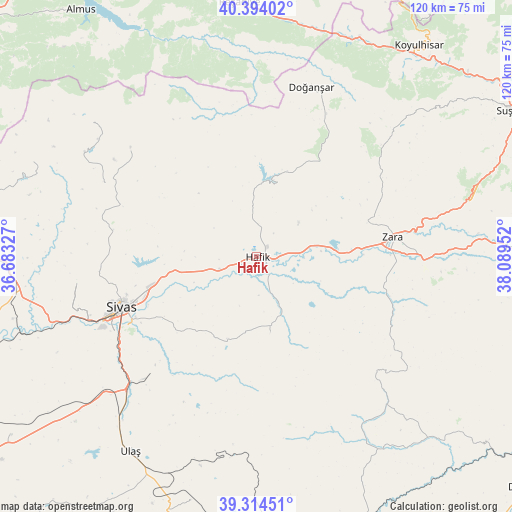
Hafik GPS coordinates[2]
39° 51' 23.004" North, 37° 23' 11.004" East
| Map corner | latitude | longitude |
|---|---|---|
| Upper-left | 40.39402°, | 36.68327° |
| Center: | 39.85639°, | 37.38639° |
| Lower-right: | 39.31451°, | 38.08952° |
| Map W x H: | 120×120 km | = 74.6×74.6mi |
| max Lat: | 42.02683° ⇑33.3% North |
| Hafik: | 39.85639° |
| min Lat: | ⇓66.7% South 35.9025° |
| min Long | Hafik | max Long |
| 25.90902° | 37.38639° | 44.60099° |
| W 58.2%⇐ | ⇒41.8% E |
Elevation
Elevation of Hafik is 1304 m = 4278 ft, and this is 586.6 m = 1925 ft above average elevation for this country.
| Max E: |
2682 m = 8799 ft | 15.2% |
| Hafik | 1304 m 4278 ft | |
| Avg. | 717.4 m = 2354 ft | |
Min E: |
0 m = 0 ft | 84.8% |
See also: Turkey elevation on elevation.city.
Geographical zone
Hafik is located in North temperate zone (between Tropic of Cancer and the Arctic Circle). Distance of this Northern Tropic circle is 1825.7 km =1134.4 mi to South.| Distance of | km | miles | from Hafik |
|---|---|---|---|
| North Pole | 5575.4 | 3464.4 | to North |
| Arctic Circle | 2969.6 | 1845.2 | to North |
| Tropic Cancer | 1825.7 | 1134.4 | to South |
| Equator | 4431.6 | 2753.7 | to South |


Nearby cities:
15 places around Hafik: (largest is in red/bold)
• Aksu
61 km =37.9 mi,  64°
64°
• Beypınarı
47.6 km =29.6 mi,  144°
144°
• Bulucan
36.2 km =22.5 mi,  118°
118°
• Celâlli
18.5 km =11.5 mi,  170°
170°
• Deliktaş
59.3 km =36.8 mi,  195°
195°
• Doğanşar
41 km =25.5 mi,  17°
17°
• Karayün
20.6 km =12.8 mi, 199°
• Koyulhisar
61.9 km =38.5 mi,  36°
36°
• Reşadiye
59.7 km =37.1 mi,  356°
356°
• Sincan
59.6 km =37 mi, 135°
• Sivas
33.8 km =21 mi,  249°
249°
• Ulaş
54.6 km =33.9 mi,  213°
213°
• Zara
32.1 km =19.9 mi,  81°
81°
• Çırçır
56.6 km =35.2 mi,  292°
292°
• Şerefiye
42.4 km =26.3 mi,  47°
47°
Sources, notices
• [Note1] Compared only with cities in Turkey existing in our database
• [Src1] Map data: © OpenStreetMap contributors (CC-BY-SA)
• [Src2] Other city data from geonames.org with taken over terms of usage.
• [Src3] Geographical zone / Annual Mean Temperature by Robert A. Rohde @ Wikipedia
