Bahşılı geodata
Bahşılı (Kırıkkale) is a seat of a second-order administrative division; located in Turkey in Europe/Istanbul (GMT+3) time zone. In our database, there are 1323 cities with bigger population. Compared to other cities in Turkey, 65.7% of cities are located further ↓South; 60.8% of cities are located further →East and 56.8% of cities have lower elevation than Bahşılı. Note1


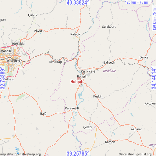
Bahşılı GPS coordinates[2]
39° 48' 0.612" North, 33° 26' 13.236" East
| Map corner | latitude | longitude |
|---|---|---|
| Upper-left | 40.33824°, | 32.73389° |
| Center: | 39.80017°, | 33.43701° |
| Lower-right: | 39.25785°, | 34.14014° |
| Map W x H: | 120.1×120.1 km | = 74.6×74.6mi |
| max Lat: | 42.02683° ⇑34.3% North |
| Bahşılı: | 39.80017° |
| min Lat: | ⇓65.7% South 35.9025° |
| min Long | Bahşılı | max Long |
| 25.90902° | 33.43701° | 44.60099° |
| W 39.2%⇐ | ⇒60.8% E |
Elevation
Elevation of Bahşılı is 825 m = 2707 ft, and this is 107.6 m = 353 ft above average elevation for this country.
| Max E: |
2682 m = 8799 ft | 43.2% |
| Bahşılı | 825 m 2707 ft | |
| Avg. | 717.4 m = 2354 ft | |
Min E: |
0 m = 0 ft | 56.8% |
See also: Turkey elevation on elevation.city.
Geographical zone
Bahşılı is located in North temperate zone (between Tropic of Cancer and the Arctic Circle). Distance of this Northern Tropic circle is 1819.4 km =1130.5 mi to South.| Distance of | km | miles | from Bahşılı |
|---|---|---|---|
| North Pole | 5581.7 | 3468.3 | to North |
| Arctic Circle | 2975.8 | 1849.1 | to North |
| Tropic Cancer | 1819.4 | 1130.5 | to South |
| Equator | 4425.4 | 2749.8 | to South |


Nearby cities:
15 places around Bahşılı: (largest is in red/bold)
• Akyurt
47.8 km =29.7 mi,  321°
321°
• Bala
38.3 km =23.8 mi,  224°
224°
• Balışeyh
27.5 km =17.1 mi,  62°
62°
• Elmadağ
22.1 km =13.7 mi,  307°
307°
• Hasayaz
49.9 km =31 mi,  349°
349°
• Kalecik
33.1 km =20.6 mi,  355°
355°
• Karakeçili
23.5 km =14.6 mi,  192°
192°
• Keskin
20.7 km =12.9 mi,  133°
133°
• Kırıkkale
7.8 km =4.8 mi,  49°
49°
• Mamak
47.6 km =29.6 mi,  289°
289°
• Sulakyurt
46.3 km =28.8 mi,  30°
30°
• Yahşihan
5.7 km =3.5 mi,  13°
13°
• Çandır
50.9 km =31.6 mi,  3°
3°
• Çankaya
50.7 km =31.5 mi,  284°
284°
• Çelebi
38.1 km =23.7 mi,  168°
168°
Sources, notices
• [Note1] Compared only with cities in Turkey existing in our database
• [Src1] Map data: © OpenStreetMap contributors (CC-BY-SA)
• [Src2] Other city data from geonames.org with taken over terms of usage.
• [Src3] Geographical zone / Annual Mean Temperature by Robert A. Rohde @ Wikipedia
