Keskin geodata
Keskin (Kırıkkale) is a seat of a second-order administrative division; located in Turkey in Europe/Istanbul (GMT+3) time zone. With population of 49,679 people, there are 176 cities with bigger population in this country. Compared to other cities in Turkey, 63.8% of cities are located further ↓South; 59.9% of cities are located further →East and 77.3% of cities have lower elevation than Keskin. Note1


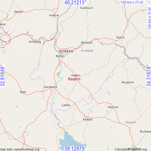
Keskin GPS coordinates[2]
39° 40' 23.016" North, 33° 36' 48.996" East
| Map corner | latitude | longitude |
|---|---|---|
| Upper-left | 40.21213°, | 32.91049° |
| Center: | 39.67306°, | 33.61361° |
| Lower-right: | 39.12975°, | 34.31674° |
| Map W x H: | 120.3×120.3 km | = 74.8×74.8mi |
| max Lat: | 42.02683° ⇑36.2% North |
| Keskin: | 39.67306° |
| min Lat: | ⇓63.8% South 35.9025° |
| min Long | Keskin | max Long |
| 25.90902° | 33.61361° | 44.60099° |
| W 40.1%⇐ | ⇒59.9% E |
Elevation
Elevation of Keskin is 1140 m = 3740 ft, and this is 422.6 m = 1386 ft above average elevation for this country.
| Max E: |
2682 m = 8799 ft | 22.7% |
| Keskin | 1140 m 3740 ft | |
| Avg. | 717.4 m = 2354 ft | |
Min E: |
0 m = 0 ft | 77.3% |
See also: Keskin elevation on elevation.city.
Geographical zone
Keskin is located in North temperate zone (between Tropic of Cancer and the Arctic Circle). Distance of this Northern Tropic circle is 1805.3 km =1121.8 mi to South.| Distance of | km | miles | from Keskin |
|---|---|---|---|
| North Pole | 5595.8 | 3477.1 | to North |
| Arctic Circle | 2989.9 | 1857.8 | to North |
| Tropic Cancer | 1805.3 | 1121.8 | to South |
| Equator | 4411.2 | 2741 | to South |


Nearby cities:
15 places around Keskin: (largest is in red/bold)
• Akpınar
39 km =24.2 mi,  129°
129°
• Akçakent
41.7 km =25.9 mi,  97°
97°
• Bahşılı
20.7 km =12.9 mi,  313°
313°
• Bala
44 km =27.3 mi,  252°
252°
• Balışeyh
28.4 km =17.6 mi,  19°
19°
• Delice
47 km =29.2 mi,  48°
48°
• Elmadağ
42.8 km =26.6 mi, 310°
• Kalecik
50.3 km =31.3 mi,  339°
339°
• Kaman
36.3 km =22.6 mi,  164°
164°
• Karakeçili
22 km =13.7 mi, 246°
• Kösefakılı
45.6 km =28.3 mi, 101°
• Kırıkkale
21.2 km =13.2 mi,  334°
334°
• Savcılı
49.7 km =30.9 mi,  173°
173°
• Yahşihan
24 km =14.9 mi, 325°
• Çelebi
24.5 km =15.2 mi,  198°
198°
Sources, notices
• [Note1] Compared only with cities in Turkey existing in our database
• [Src1] Map data: © OpenStreetMap contributors (CC-BY-SA)
• [Src2] Other city data from geonames.org with taken over terms of usage.
• [Src3] Geographical zone / Annual Mean Temperature by Robert A. Rohde @ Wikipedia
