Kaman geodata
Kaman (Kırşehir) is a seat of a second-order administrative division; located in Turkey in Europe/Istanbul (GMT+3) time zone. With population of 28,605 people, there are 262 cities with bigger population in this country. Compared to other cities in Turkey, 59.6% of cities are located further ↓South; 59.4% of cities are located further →East and 76.3% of cities have lower elevation than Kaman. Note1


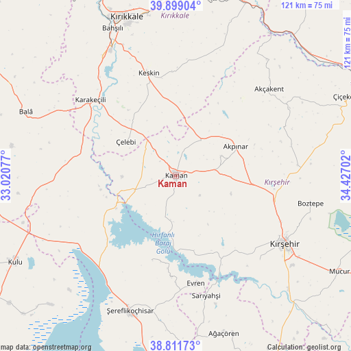
Kaman GPS coordinates[2]
39° 21' 27" North, 33° 43' 26.004" East
| Map corner | latitude | longitude |
|---|---|---|
| Upper-left | 39.89904°, | 33.02077° |
| Center: | 39.3575°, | 33.72389° |
| Lower-right: | 38.81173°, | 34.42702° |
| Map W x H: | 120.9×120.9 km | = 75.1×75.1mi |
| max Lat: | 42.02683° ⇑40.4% North |
| Kaman: | 39.3575° |
| min Lat: | ⇓59.6% South 35.9025° |
| min Long | Kaman | max Long |
| 25.90902° | 33.72389° | 44.60099° |
| W 40.6%⇐ | ⇒59.4% E |
Elevation
Elevation of Kaman is 1126 m = 3694 ft, and this is 408.6 m = 1341 ft above average elevation for this country.
| Max E: |
2682 m = 8799 ft | 23.7% |
| Kaman | 1126 m 3694 ft | |
| Avg. | 717.4 m = 2354 ft | |
Min E: |
0 m = 0 ft | 76.3% |
See also: Turkey elevation on elevation.city.
Geographical zone
Kaman is located in North temperate zone (between Tropic of Cancer and the Arctic Circle). Distance of this Northern Tropic circle is 1770.2 km =1100 mi to South.| Distance of | km | miles | from Kaman |
|---|---|---|---|
| North Pole | 5630.9 | 3498.9 | to North |
| Arctic Circle | 3025 | 1879.6 | to North |
| Tropic Cancer | 1770.2 | 1100 | to South |
| Equator | 4376.1 | 2719.2 | to South |


Nearby cities:
15 places around Kaman: (largest is in red/bold)
• Akpınar
23.1 km =14.4 mi,  63°
63°
• Akçakent
43.5 km =27 mi,  47°
47°
• Bahşılı
55 km =34.2 mi,  333°
333°
• Bala
56 km =34.8 mi,  292°
292°
• Boztepe
47.2 km =29.3 mi,  101°
101°
• Evren
37.8 km =23.5 mi,  169°
169°
• Göllü
50.6 km =31.4 mi,  78°
78°
• Karakeçili
39.7 km =24.7 mi,  311°
311°
• Keskin
36.3 km =22.6 mi,  344°
344°
• Kösefakılı
44.1 km =27.4 mi, 53°
• Kırşehir
44.6 km =27.7 mi,  121°
121°
• Sarıyahşi
42.8 km =26.6 mi, 166°
• Savcılı
14.8 km =9.2 mi,  194°
194°
• Çelebi
20.9 km =13 mi,  304°
304°
• Şereflikoçhisar
49.2 km =30.6 mi,  198°
198°
Sources, notices
• [Note1] Compared only with cities in Turkey existing in our database
• [Src1] Map data: © OpenStreetMap contributors (CC-BY-SA)
• [Src2] Other city data from geonames.org with taken over terms of usage.
• [Src3] Geographical zone / Annual Mean Temperature by Robert A. Rohde @ Wikipedia
