Aksu geodata
Aksu (Isparta) is a seat of a second-order administrative division; located in Turkey in Europe/Istanbul (GMT+3) time zone. With population of 3,842 people, there are 791 cities with bigger population in this country. Compared to other cities in Turkey, 68.5% of cities are located further ↑North; 70.2% of cities are located further →East and 81.7% of cities have lower elevation than Aksu. Note1


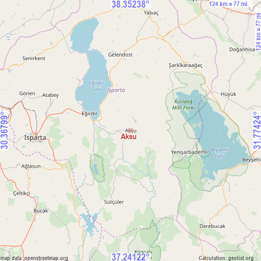
Aksu GPS coordinates[2]
37° 47' 56.004" North, 31° 4' 15.996" East
| Map corner | latitude | longitude |
|---|---|---|
| Upper-left | 38.35238°, | 30.36799° |
| Center: | 37.79889°, | 31.07111° |
| Lower-right: | 37.24122°, | 31.77424° |
| Map W x H: | 123.5×123.5 km | = 76.7×76.7mi |
| max Lat: | 42.02683° ⇑68.5% North |
| Aksu: | 37.79889° |
| min Lat: | ⇓31.5% South 35.9025° |
| min Long | Aksu | max Long |
| 25.90902° | 31.07111° | 44.60099° |
| W 29.8%⇐ | ⇒70.2% E |
Elevation
Elevation of Aksu is 1229 m = 4032 ft, and this is 511.6 m = 1678 ft above average elevation for this country.
| Max E: |
2682 m = 8799 ft | 18.3% |
| Aksu | 1229 m 4032 ft | |
| Avg. | 717.4 m = 2354 ft | |
Min E: |
0 m = 0 ft | 81.7% |
See also: Turkey elevation on elevation.city.
Geographical zone
Aksu is located in North temperate zone (between Tropic of Cancer and the Arctic Circle). Distance of this Northern Tropic circle is 1596.9 km =992.3 mi to South.| Distance of | km | miles | from Aksu |
|---|---|---|---|
| North Pole | 5804.2 | 3606.6 | to North |
| Arctic Circle | 3198.3 | 1987.3 | to North |
| Tropic Cancer | 1596.9 | 992.3 | to South |
| Equator | 4202.8 | 2611.5 | to South |


Nearby cities:
15 places around Aksu: (largest is in red/bold)
• Anamas
24.1 km =15 mi,  261°
261°
• Atabey
41.5 km =25.8 mi,  293°
293°
• Ağlasun
50.1 km =31.1 mi,  250°
250°
• Barla
35.1 km =21.8 mi,  313°
313°
• Bağkonak
49.8 km =30.9 mi,  20°
20°
• Eğirdir
21.1 km =13.1 mi, 293°
• Gelendost
36.1 km =22.4 mi,  352°
352°
• Gönen
52.2 km =32.4 mi, 289°
• Hüyük
49.2 km =30.6 mi,  69°
69°
• Isparta
45.8 km =28.5 mi,  265°
265°
• Kasımlar
31.9 km =19.8 mi,  160°
160°
• Pavlu Cebel
34.5 km =21.4 mi,  193°
193°
• Yenişarbademli
29.5 km =18.3 mi,  110°
110°
• Üzümlü
55 km =34.2 mi,  121°
121°
• Şarkîkaraağaç
40.5 km =25.2 mi,  39°
39°
Sources, notices
• [Note1] Compared only with cities in Turkey existing in our database
• [Src1] Map data: © OpenStreetMap contributors (CC-BY-SA)
• [Src2] Other city data from geonames.org with taken over terms of usage.
• [Src3] Geographical zone / Annual Mean Temperature by Robert A. Rohde @ Wikipedia
