Hüyük geodata
Hüyük (Konya) is a seat of a second-order administrative division; located in Turkey in Europe/Istanbul (GMT+3) time zone. With population of 11,502 people, there are 466 cities with bigger population in this country. Compared to other cities in Turkey, 62.7% of cities are located further ↑North; 68.5% of cities are located further →East and 82.6% of cities have lower elevation than Hüyük. Note1


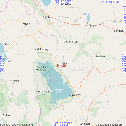
Hüyük GPS coordinates[2]
37° 57' 13.968" North, 31° 35' 47.004" East
| Map corner | latitude | longitude |
|---|---|---|
| Upper-left | 38.5062°, | 30.89327° |
| Center: | 37.95388°, | 31.59639° |
| Lower-right: | 37.39737°, | 32.29952° |
| Map W x H: | 123.3×123.3 km | = 76.6×76.6mi |
| max Lat: | 42.02683° ⇑62.7% North |
| Hüyük: | 37.95388° |
| min Lat: | ⇓37.3% South 35.9025° |
| min Long | Hüyük | max Long |
| 25.90902° | 31.59639° | 44.60099° |
| W 31.5%⇐ | ⇒68.5% E |
Elevation
Elevation of Hüyük is 1249 m = 4098 ft, and this is 531.6 m = 1744 ft above average elevation for this country.
| Max E: |
2682 m = 8799 ft | 17.4% |
| Hüyük | 1249 m 4098 ft | |
| Avg. | 717.4 m = 2354 ft | |
Min E: |
0 m = 0 ft | 82.6% |
See also: Turkey elevation on elevation.city.
Geographical zone
Hüyük is located in North temperate zone (between Tropic of Cancer and the Arctic Circle). Distance of this Northern Tropic circle is 1614.2 km =1003 mi to South.| Distance of | km | miles | from Hüyük |
|---|---|---|---|
| North Pole | 5787 | 3595.9 | to North |
| Arctic Circle | 3181.1 | 1976.6 | to North |
| Tropic Cancer | 1614.2 | 1003 | to South |
| Equator | 4220.1 | 2622.2 | to South |


Nearby cities:
15 places around Hüyük: (largest is in red/bold)
• Akşehir
47.6 km =29.6 mi,  340°
340°
• Argıthanı
39.1 km =24.3 mi,  15°
15°
• Aşağıçiğil
25.8 km =16 mi,  65°
65°
• Bağkonak
40.8 km =25.4 mi,  315°
315°
• Beyşehir
32.7 km =20.3 mi,  159°
159°
• Derbent
37.4 km =23.2 mi,  79°
79°
• Doğanbey
31 km =19.3 mi,  123°
123°
• Doğanhisar
22.5 km =14 mi, 18°
• Ilgın
45.6 km =28.3 mi,  37°
37°
• Kızılören
46.6 km =29 mi,  101°
101°
• Reis
35.4 km =22 mi,  356°
356°
• Yenişarbademli
33 km =20.5 mi,  213°
213°
• Çavuş
48.3 km =30 mi,  142°
142°
• Üzümlü
46 km =28.6 mi,  179°
179°
• Şarkîkaraağaç
24.5 km =15.2 mi,  304°
304°
Sources, notices
• [Note1] Compared only with cities in Turkey existing in our database
• [Src1] Map data: © OpenStreetMap contributors (CC-BY-SA)
• [Src2] Other city data from geonames.org with taken over terms of usage.
• [Src3] Geographical zone / Annual Mean Temperature by Robert A. Rohde @ Wikipedia
