Şarkîkaraağaç geodata
Şarkîkaraağaç (Isparta) is a seat of a second-order administrative division; located in Turkey in Europe/Istanbul (GMT+3) time zone. With population of 32,771 people, there are 232 cities with bigger population in this country. Compared to other cities in Turkey, 60.2% of cities are located further ↑North; 69.2% of cities are located further →East and 78.7% of cities have lower elevation than Şarkîkaraağaç. Note1


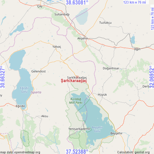
Şarkîkaraağaç GPS coordinates[2]
38° 4' 45.984" North, 31° 21' 59.004" East
| Map corner | latitude | longitude |
|---|---|---|
| Upper-left | 38.63081°, | 30.66327° |
| Center: | 38.07944°, | 31.36639° |
| Lower-right: | 37.52388°, | 32.06952° |
| Map W x H: | 123.1×123.1 km | = 76.5×76.5mi |
| max Lat: | 42.02683° ⇑60.2% North |
| Şarkîkaraağaç: | 38.07944° |
| min Lat: | ⇓39.8% South 35.9025° |
| min Long | Şarkîkaraağa | max Long |
| 25.90902° | 31.36639° | 44.60099° |
| W 30.8%⇐ | ⇒69.2% E |
Elevation
Elevation of Şarkîkaraağaç is 1170 m = 3839 ft, and this is 452.6 m = 1485 ft above average elevation for this country.
| Max E: |
2682 m = 8799 ft | 21.3% |
| Şarkîkaraağaç | 1170 m 3839 ft | |
| Avg. | 717.4 m = 2354 ft | |
Min E: |
0 m = 0 ft | 78.7% |
See also: Turkey elevation on elevation.city.
Geographical zone
Şarkîkaraağaç is located in North temperate zone (between Tropic of Cancer and the Arctic Circle). Distance of this Northern Tropic circle is 1628.1 km =1011.7 mi to South.| Distance of | km | miles | from Şarkîkaraağaç |
|---|---|---|---|
| North Pole | 5773 | 3587.2 | to North |
| Arctic Circle | 3167.1 | 1967.9 | to North |
| Tropic Cancer | 1628.1 | 1011.7 | to South |
| Equator | 4234 | 2630.9 | to South |


Nearby cities:
15 places around Şarkîkaraağaç: (largest is in red/bold)
• Aksu
40.5 km =25.2 mi,  219°
219°
• Akşehir
31.2 km =19.4 mi,  8°
8°
• Argıthanı
38.6 km =24 mi,  52°
52°
• Aşağıçiğil
43.7 km =27.2 mi,  94°
94°
• Barla
51.6 km =32.1 mi,  262°
262°
• Bağkonak
17.4 km =10.8 mi,  331°
331°
• Doğanhisar
28.1 km =17.5 mi,  74°
74°
• Eğirdir
50.6 km =31.4 mi,  243°
243°
• Gelendost
31.1 km =19.3 mi,  278°
278°
• Hüyük
24.5 km =15.2 mi,  124°
124°
• Kumdanlı
43.6 km =27.1 mi,  308°
308°
• Reis
27.9 km =17.3 mi,  40°
40°
• Tuzlukçu
49.8 km =30.9 mi,  27°
27°
• Yalvaç
29.1 km =18.1 mi, 325°
• Yenişarbademli
41.4 km =25.7 mi,  177°
177°
Sources, notices
• [Note1] Compared only with cities in Turkey existing in our database
• [Src1] Map data: © OpenStreetMap contributors (CC-BY-SA)
• [Src2] Other city data from geonames.org with taken over terms of usage.
• [Src3] Geographical zone / Annual Mean Temperature by Robert A. Rohde @ Wikipedia
