Kızılören geodata
Kızılören (Konya) is a seat of a third-order administrative division; located in Turkey in Europe/Istanbul (GMT+3) time zone. In our database, there are 1323 cities with bigger population. Compared to other cities in Turkey, 66.4% of cities are located further ↑North; 66.1% of cities are located further →East and 90.2% of cities have lower elevation than Kızılören. Note1


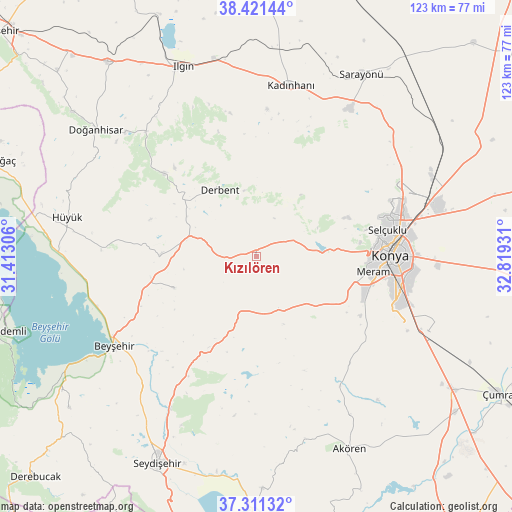
Kızılören GPS coordinates[2]
37° 52' 6.492" North, 32° 6' 58.248" East
| Map corner | latitude | longitude |
|---|---|---|
| Upper-left | 38.42144°, | 31.41306° |
| Center: | 37.86847°, | 32.11618° |
| Lower-right: | 37.31132°, | 32.81931° |
| Map W x H: | 123.4×123.4 km | = 76.7×76.7mi |
| max Lat: | 42.02683° ⇑66.4% North |
| Kızılören: | 37.86847° |
| min Lat: | ⇓33.6% South 35.9025° |
| min Long | Kızılören | max Long |
| 25.90902° | 32.11618° | 44.60099° |
| W 33.9%⇐ | ⇒66.1% E |
Elevation
Elevation of Kızılören is 1484 m = 4869 ft, and this is 766.6 m = 2515 ft above average elevation for this country.
| Max E: |
2682 m = 8799 ft | 9.8% |
| Kızılören | 1484 m 4869 ft | |
| Avg. | 717.4 m = 2354 ft | |
Min E: |
0 m = 0 ft | 90.2% |
See also: Turkey elevation on elevation.city.
Geographical zone
Kızılören is located in North temperate zone (between Tropic of Cancer and the Arctic Circle). Distance of this Northern Tropic circle is 1604.7 km =997.1 mi to South.| Distance of | km | miles | from Kızılören |
|---|---|---|---|
| North Pole | 5796.5 | 3601.8 | to North |
| Arctic Circle | 3190.6 | 1982.5 | to North |
| Tropic Cancer | 1604.7 | 997.1 | to South |
| Equator | 4210.6 | 2616.3 | to South |


Nearby cities:
15 places around Kızılören: (largest is in red/bold)
• Aşağıpınarbaşı
46.5 km =28.9 mi,  66°
66°
• Aşağıçiğil
30.1 km =18.7 mi,  312°
312°
• Beyşehir
40.4 km =25.1 mi,  238°
238°
• Derbent
18.4 km =11.4 mi,  331°
331°
• Doğanbey
21.2 km =13.2 mi,  249°
249°
• Hatip
29.7 km =18.5 mi,  115°
115°
• Hatunsaray
37.3 km =23.2 mi,  146°
146°
• Hüyük
46.6 km =29 mi,  281°
281°
• Kadınhanı
42.1 km =26.2 mi,  11°
11°
• Karatay
36.2 km =22.5 mi,  90°
90°
• Konya
32.3 km =20.1 mi, 89°
• Meram
31.2 km =19.4 mi,  97°
97°
• Selçuklu
33 km =20.5 mi, 86°
• Sille
27.4 km =17 mi,  76°
76°
• Çavuş
33.1 km =20.6 mi,  209°
209°
Sources, notices
• [Note1] Compared only with cities in Turkey existing in our database
• [Src1] Map data: © OpenStreetMap contributors (CC-BY-SA)
• [Src2] Other city data from geonames.org with taken over terms of usage.
• [Src3] Geographical zone / Annual Mean Temperature by Robert A. Rohde @ Wikipedia
