Kesmeköprü geodata
Kesmeköprü (Batman) is a populated place; located in Turkey in Europe/Istanbul (GMT+3) time zone. With population of 877 people, there are 1124 cities with bigger population in this country. Compared to other cities in Turkey, 70.2% of cities are located further ↑North; 85.5% of cities are located further ←West and 61.7% of cities have higher elevation than Kesmeköprü. Note1


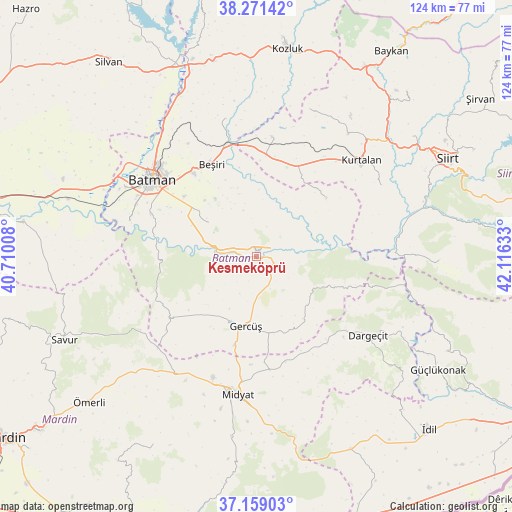
Kesmeköprü GPS coordinates[2]
37° 43' 2.316" North, 41° 24' 47.52" East
| Map corner | latitude | longitude |
|---|---|---|
| Upper-left | 38.27142°, | 40.71008° |
| Center: | 37.71731°, | 41.4132° |
| Lower-right: | 37.15903°, | 42.11633° |
| Map W x H: | 123.7×123.7 km | = 76.9×76.9mi |
| max Lat: | 42.02683° ⇑70.2% North |
| Kesmeköprü: | 37.71731° |
| min Lat: | ⇓29.8% South 35.9025° |
| min Long | Kesmeköprü | max Long |
| 25.90902° | 41.4132° | 44.60099° |
| W 85.5%⇐ | ⇒14.5% E |
Elevation
Elevation of Kesmeköprü is 480 m = 1575 ft, and this is 237.4 m = 779 ft below average elevation for this country.
| Max E: |
2682 m = 8799 ft | 61.7% |
| Avg. | 717.4 m = 2354 ft | |
| Kesmeköprü | 480 m = 1575 ft | |
Min E: |
0 m = 0 ft | 38.3% |
See also: Turkey elevation on elevation.city.
Geographical zone
Kesmeköprü is located in North temperate zone (between Tropic of Cancer and the Arctic Circle). Distance of this Northern Tropic circle is 1587.9 km =986.7 mi to South.| Distance of | km | miles | from Kesmeköprü |
|---|---|---|---|
| North Pole | 5813.3 | 3612.2 | to North |
| Arctic Circle | 3207.4 | 1993 | to North |
| Tropic Cancer | 1587.9 | 986.7 | to South |
| Equator | 4193.8 | 2605.9 | to South |


Nearby cities:
15 places around Kesmeköprü: (largest is in red/bold)
• Asmadere
21.8 km =13.5 mi,  349°
349°
• Beşpınar
21.3 km =13.2 mi,  51°
51°
• Derdil
10.5 km =6.5 mi,  139°
139°
• Gerdzhyush
17.5 km =10.9 mi,  190°
190°
• Gökçepınar
17.1 km =10.6 mi,  146°
146°
• Hasankeyf
1.4 km =0.9 mi,  210°
210°
• Hisar
20.8 km =12.9 mi,  231°
231°
• Karaköy
3.8 km =2.4 mi,  181°
181°
• Kozlu
9.7 km =6 mi,  203°
203°
• Oğuz
11.4 km =7.1 mi,  342°
342°
• Yenipınar
17.1 km =10.6 mi,  324°
324°
• Yolağzı
22 km =13.7 mi, 193°
• Yontukyazı
19.9 km =12.4 mi, 338°
• Çevrimova
18.4 km =11.4 mi, 317°
• Çukuryurt
15.5 km =9.6 mi,  156°
156°
Sources, notices
• [Note1] Compared only with cities in Turkey existing in our database
• [Src1] Map data: © OpenStreetMap contributors (CC-BY-SA)
• [Src2] Other city data from geonames.org with taken over terms of usage.
• [Src3] Geographical zone / Annual Mean Temperature by Robert A. Rohde @ Wikipedia
