Hekimdağ geodata
Hekimdağ (Eskişehir) is a seat of a third-order administrative division; located in Turkey in Europe/Istanbul (GMT+3) time zone. In our database, there are 1323 cities with bigger population. Compared to other cities in Turkey, 67.5% of cities are located further ↓South; 72.4% of cities are located further →East and 82.6% of cities have lower elevation than Hekimdağ. Note1


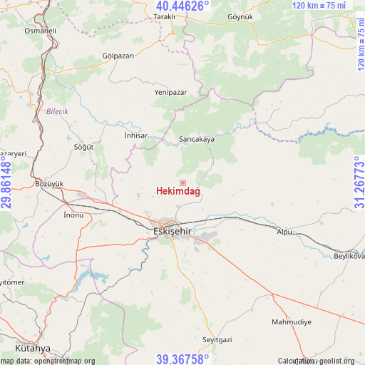
Hekimdağ GPS coordinates[2]
39° 54' 32.544" North, 30° 33' 52.56" East
| Map corner | latitude | longitude |
|---|---|---|
| Upper-left | 40.44626°, | 29.86148° |
| Center: | 39.90904°, | 30.5646° |
| Lower-right: | 39.36758°, | 31.26773° |
| Map W x H: | 119.9×119.9 km | = 74.5×74.5mi |
| max Lat: | 42.02683° ⇑32.5% North |
| Hekimdağ: | 39.90904° |
| min Lat: | ⇓67.5% South 35.9025° |
| min Long | Hekimdağ | max Long |
| 25.90902° | 30.5646° | 44.60099° |
| W 27.6%⇐ | ⇒72.4% E |
Elevation
Elevation of Hekimdağ is 1249 m = 4098 ft, and this is 531.6 m = 1744 ft above average elevation for this country.
| Max E: |
2682 m = 8799 ft | 17.4% |
| Hekimdağ | 1249 m 4098 ft | |
| Avg. | 717.4 m = 2354 ft | |
Min E: |
0 m = 0 ft | 82.6% |
See also: Turkey elevation on elevation.city.
Geographical zone
Hekimdağ is located in North temperate zone (between Tropic of Cancer and the Arctic Circle). Distance of this Northern Tropic circle is 1831.6 km =1138.1 mi to South.| Distance of | km | miles | from Hekimdağ |
|---|---|---|---|
| North Pole | 5569.6 | 3460.8 | to North |
| Arctic Circle | 2963.7 | 1841.6 | to North |
| Tropic Cancer | 1831.6 | 1138.1 | to South |
| Equator | 4437.5 | 2757.3 | to South |


Nearby cities:
15 places around Hekimdağ: (largest is in red/bold)
• Alpu
37.2 km =23.1 mi,  114°
114°
• Bozan
47.8 km =29.7 mi, 106°
• Bozüyük
45 km =28 mi,  269°
269°
• Eskişehir
15.2 km =9.4 mi,  194°
194°
• Gölpazarı
46.8 km =29.1 mi,  333°
333°
• Mihalgazi
13.1 km =8.1 mi,  4°
4°
• Odunpazarı
15.9 km =9.9 mi, 189°
• Sabuncu
50.3 km =31.3 mi,  219°
219°
• Sarıcakaya
15.2 km =9.4 mi,  20°
20°
• Sevinç
17.8 km =11.1 mi,  143°
143°
• Söğüt
34.4 km =21.4 mi,  289°
289°
• Tepebaşı
11.4 km =7.1 mi,  197°
197°
• Yenipazar
30.2 km =18.8 mi,  352°
352°
• İnhisar
21.8 km =13.5 mi,  315°
315°
• İnönü
37.3 km =23.2 mi,  253°
253°
Sources, notices
• [Note1] Compared only with cities in Turkey existing in our database
• [Src1] Map data: © OpenStreetMap contributors (CC-BY-SA)
• [Src2] Other city data from geonames.org with taken over terms of usage.
• [Src3] Geographical zone / Annual Mean Temperature by Robert A. Rohde @ Wikipedia
