İnhisar geodata
İnhisar (Bilecik) is a seat of a second-order administrative division; located in Turkey in Europe/Istanbul (GMT+3) time zone. With population of 2,718 people, there are 878 cities with bigger population in this country. Compared to other cities in Turkey, 70% of cities are located further ↓South; 73.8% of cities are located further →East and 72.4% of cities have higher elevation than İnhisar. Note1


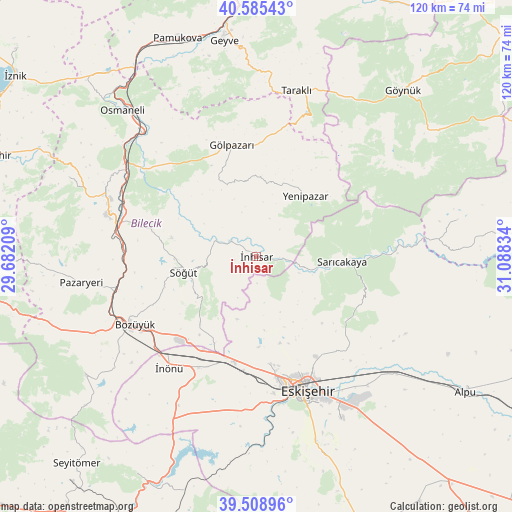
İnhisar GPS coordinates[2]
40° 2' 57.552" North, 30° 23' 6.756" East
| Map corner | latitude | longitude |
|---|---|---|
| Upper-left | 40.58543°, | 29.68209° |
| Center: | 40.04932°, | 30.38521° |
| Lower-right: | 39.50896°, | 31.08834° |
| Map W x H: | 119.7×119.7 km | = 74.4×74.4mi |
| max Lat: | 42.02683° ⇑30% North |
| İnhisar: | 40.04932° |
| min Lat: | ⇓70% South 35.9025° |
| min Long | İnhisar | max Long |
| 25.90902° | 30.38521° | 44.60099° |
| W 26.2%⇐ | ⇒73.8% E |
Elevation
Elevation of İnhisar is 227 m = 745 ft, and this is 490.4 m = 1609 ft below average elevation for this country.
| Max E: |
2682 m = 8799 ft | 72.4% |
| Avg. | 717.4 m = 2354 ft | |
| İnhisar | 227 m = 745 ft | |
Min E: |
0 m = 0 ft | 27.6% |
See also: Turkey elevation on elevation.city.
Geographical zone
İnhisar is located in North temperate zone (between Tropic of Cancer and the Arctic Circle). Distance of this Northern Tropic circle is 1847.1 km =1147.7 mi to South.| Distance of | km | miles | from İnhisar |
|---|---|---|---|
| North Pole | 5554 | 3451.1 | to North |
| Arctic Circle | 2948.1 | 1831.9 | to North |
| Tropic Cancer | 1847.1 | 1147.7 | to South |
| Equator | 4453.1 | 2767 | to South |


Nearby cities:
15 places around İnhisar: (largest is in red/bold)
• Bilecik
36 km =22.4 mi,  286°
286°
• Bozüyük
33.6 km =20.9 mi,  242°
242°
• Eskişehir
32.4 km =20.1 mi,  159°
159°
• Gölpazarı
26.8 km =16.7 mi,  347°
347°
• Hekimdağ
21.8 km =13.5 mi,  135°
135°
• Küplü
33.2 km =20.6 mi,  279°
279°
• Mihalgazi
16.5 km =10.3 mi,  98°
98°
• Odunpazarı
33.8 km =21 mi, 157°
• Sarıcakaya
20.6 km =12.8 mi,  93°
93°
• Sevinç
39.6 km =24.6 mi, 139°
• Söğüt
17.5 km =10.9 mi,  257°
257°
• Tepebaşı
29.1 km =18.1 mi, 155°
• Vezirhan
37.9 km =23.5 mi,  304°
304°
• Yenipazar
18.4 km =11.4 mi,  38°
38°
• İnönü
33.1 km =20.6 mi,  218°
218°
Sources, notices
• [Note1] Compared only with cities in Turkey existing in our database
• [Src1] Map data: © OpenStreetMap contributors (CC-BY-SA)
• [Src2] Other city data from geonames.org with taken over terms of usage.
• [Src3] Geographical zone / Annual Mean Temperature by Robert A. Rohde @ Wikipedia
