Tepebaşı geodata
Tepebaşı (Eskişehir) is a seat of a second-order administrative division; located in Turkey in Europe/Istanbul (GMT+3) time zone. In our database, there are 1323 cities with bigger population. Compared to other cities in Turkey, 66% of cities are located further ↓South; 73% of cities are located further →East and 54.7% of cities have lower elevation than Tepebaşı. Note1


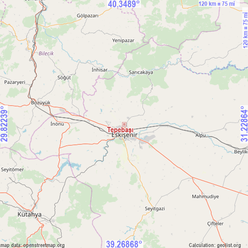
Tepebaşı GPS coordinates[2]
39° 48' 39.276" North, 30° 31' 31.836" East
| Map corner | latitude | longitude |
|---|---|---|
| Upper-left | 40.3489°, | 29.82239° |
| Center: | 39.81091°, | 30.52551° |
| Lower-right: | 39.26868°, | 31.22864° |
| Map W x H: | 120.1×120.1 km | = 74.6×74.6mi |
| max Lat: | 42.02683° ⇑34% North |
| Tepebaşı: | 39.81091° |
| min Lat: | ⇓66% South 35.9025° |
| min Long | Tepebaşı | max Long |
| 25.90902° | 30.52551° | 44.60099° |
| W 27%⇐ | ⇒73% E |
Elevation
Elevation of Tepebaşı is 787 m = 2582 ft, and this is 69.6 m = 228 ft above average elevation for this country.
| Max E: |
2682 m = 8799 ft | 45.3% |
| Tepebaşı | 787 m 2582 ft | |
| Avg. | 717.4 m = 2354 ft | |
Min E: |
0 m = 0 ft | 54.7% |
See also: Turkey elevation on elevation.city.
Geographical zone
Tepebaşı is located in North temperate zone (between Tropic of Cancer and the Arctic Circle). Distance of this Northern Tropic circle is 1820.6 km =1131.3 mi to South.| Distance of | km | miles | from Tepebaşı |
|---|---|---|---|
| North Pole | 5580.5 | 3467.6 | to North |
| Arctic Circle | 2974.6 | 1848.3 | to North |
| Tropic Cancer | 1820.6 | 1131.3 | to South |
| Equator | 4426.6 | 2750.6 | to South |


Nearby cities:
15 places around Tepebaşı: (largest is in red/bold)
• Alpu
37.5 km =23.3 mi,  97°
97°
• Bozan
49.3 km =30.6 mi,  92°
92°
• Bozüyük
43.1 km =26.8 mi,  284°
284°
• Eskişehir
3.8 km =2.4 mi,  186°
186°
• Hekimdağ
11.4 km =7.1 mi,  17°
17°
• Mihalgazi
24.3 km =15.1 mi,  10°
10°
• Odunpazarı
4.8 km =3 mi,  169°
169°
• Sabuncu
40 km =24.9 mi,  226°
226°
• Sarıcakaya
26.6 km =16.5 mi, 18°
• Sevinç
14.4 km =8.9 mi, 103°
• Seyitgazi
43.2 km =26.8 mi,  160°
160°
• Söğüt
36.8 km =22.9 mi,  307°
307°
• Yenipazar
40.9 km =25.4 mi,  359°
359°
• İnhisar
29.1 km =18.1 mi,  335°
335°
• İnönü
32.5 km =20.2 mi,  270°
270°
Sources, notices
• [Note1] Compared only with cities in Turkey existing in our database
• [Src1] Map data: © OpenStreetMap contributors (CC-BY-SA)
• [Src2] Other city data from geonames.org with taken over terms of usage.
• [Src3] Geographical zone / Annual Mean Temperature by Robert A. Rohde @ Wikipedia
