Söğüt geodata
Söğüt (Bilecik) is a seat of a second-order administrative division; located in Turkey in Europe/Istanbul (GMT+3) time zone. In our database, there are 1323 cities with bigger population. Compared to other cities in Turkey, 69.2% of cities are located further ↓South; 74.8% of cities are located further →East and 50.2% of cities have higher elevation than Söğüt. Note1


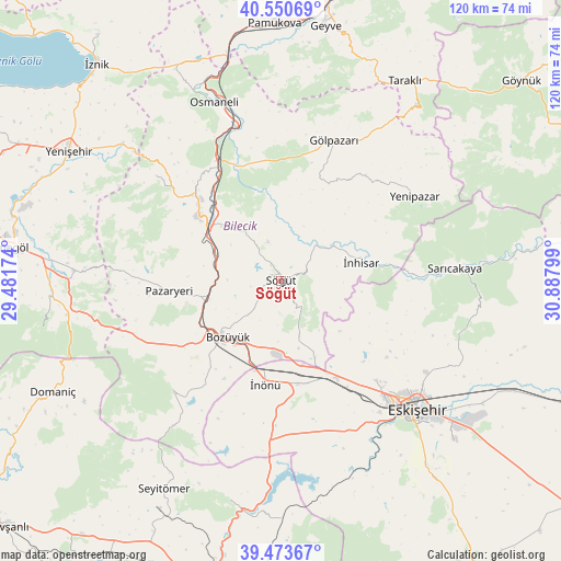
Söğüt GPS coordinates[2]
40° 0' 51.48" North, 30° 11' 5.496" East
| Map corner | latitude | longitude |
|---|---|---|
| Upper-left | 40.55069°, | 29.48174° |
| Center: | 40.0143°, | 30.18486° |
| Lower-right: | 39.47367°, | 30.88799° |
| Map W x H: | 119.8×119.8 km | = 74.4×74.4mi |
| max Lat: | 42.02683° ⇑30.8% North |
| Söğüt: | 40.0143° |
| min Lat: | ⇓69.2% South 35.9025° |
| min Long | Söğüt | max Long |
| 25.90902° | 30.18486° | 44.60099° |
| W 25.2%⇐ | ⇒74.8% E |
Elevation
Elevation of Söğüt is 690 m = 2264 ft, and this is 27.4 m = 90 ft below average elevation for this country.
| Max E: |
2682 m = 8799 ft | 50.2% |
| Avg. | 717.4 m = 2354 ft | |
| Söğüt | 690 m = 2264 ft | |
Min E: |
0 m = 0 ft | 49.8% |
See also: Turkey elevation on elevation.city.
Geographical zone
Söğüt is located in North temperate zone (between Tropic of Cancer and the Arctic Circle). Distance of this Northern Tropic circle is 1843.3 km =1145.4 mi to South.| Distance of | km | miles | from Söğüt |
|---|---|---|---|
| North Pole | 5557.9 | 3453.5 | to North |
| Arctic Circle | 2952 | 1834.3 | to North |
| Tropic Cancer | 1843.3 | 1145.4 | to South |
| Equator | 4449.2 | 2764.6 | to South |


Nearby cities:
15 places around Söğüt: (largest is in red/bold)
• Bilecik
22.5 km =14 mi,  309°
309°
• Bozüyük
17.3 km =10.7 mi,  226°
226°
• Dodurga
33 km =20.5 mi,  223°
223°
• Gölpazarı
32.1 km =19.9 mi,  20°
20°
• Hekimdağ
34.4 km =21.4 mi,  109°
109°
• Küplü
18.3 km =11.4 mi,  300°
300°
• Mihalgazi
33.4 km =20.8 mi,  87°
87°
• Pazaryeri
24 km =14.9 mi,  264°
264°
• Sarıcakaya
37.7 km =23.4 mi, 86°
• Tepebaşı
36.8 km =22.9 mi,  127°
127°
• Vezirhan
29.2 km =18.1 mi,  331°
331°
• Yarhisar
34.9 km =21.7 mi, 310°
• Yenipazar
33.8 km =21 mi,  57°
57°
• İnhisar
17.5 km =10.9 mi,  77°
77°
• İnönü
22.4 km =13.9 mi,  188°
188°
Sources, notices
• [Note1] Compared only with cities in Turkey existing in our database
• [Src1] Map data: © OpenStreetMap contributors (CC-BY-SA)
• [Src2] Other city data from geonames.org with taken over terms of usage.
• [Src3] Geographical zone / Annual Mean Temperature by Robert A. Rohde @ Wikipedia
