İnönü geodata
İnönü (Eskişehir) is a seat of a second-order administrative division; located in Turkey in Europe/Istanbul (GMT+3) time zone. In our database, there are 1323 cities with bigger population. Compared to other cities in Turkey, 66.2% of cities are located further ↓South; 75.1% of cities are located further →East and 58% of cities have lower elevation than İnönü. Note1


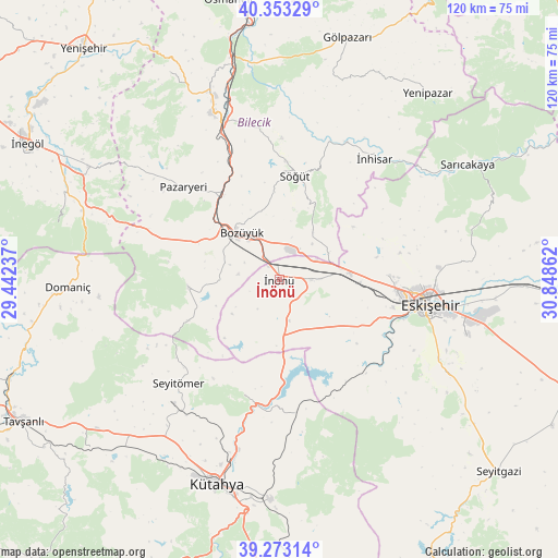
İnönü GPS coordinates[2]
39° 48' 55.224" North, 30° 8' 43.764" East
| Map corner | latitude | longitude |
|---|---|---|
| Upper-left | 40.35329°, | 29.44237° |
| Center: | 39.81534°, | 30.14549° |
| Lower-right: | 39.27314°, | 30.84862° |
| Map W x H: | 120.1×120.1 km | = 74.6×74.6mi |
| max Lat: | 42.02683° ⇑33.8% North |
| İnönü: | 39.81534° |
| min Lat: | ⇓66.2% South 35.9025° |
| min Long | İnönü | max Long |
| 25.90902° | 30.14549° | 44.60099° |
| W 24.9%⇐ | ⇒75.1% E |
Elevation
Elevation of İnönü is 844 m = 2769 ft, and this is 126.6 m = 415 ft above average elevation for this country.
| Max E: |
2682 m = 8799 ft | 42% |
| İnönü | 844 m 2769 ft | |
| Avg. | 717.4 m = 2354 ft | |
Min E: |
0 m = 0 ft | 58% |
See also: Turkey elevation on elevation.city.
Geographical zone
İnönü is located in North temperate zone (between Tropic of Cancer and the Arctic Circle). Distance of this Northern Tropic circle is 1821.1 km =1131.6 mi to South.| Distance of | km | miles | from İnönü |
|---|---|---|---|
| North Pole | 5580 | 3467.3 | to North |
| Arctic Circle | 2974.1 | 1848 | to North |
| Tropic Cancer | 1821.1 | 1131.6 | to South |
| Equator | 4427.1 | 2750.9 | to South |


Nearby cities:
15 places around İnönü: (largest is in red/bold)
• Bilecik
39 km =24.2 mi,  338°
338°
• Bozüyük
13.9 km =8.6 mi,  317°
317°
• Dodurga
19.6 km =12.2 mi,  264°
264°
• Eskişehir
32.3 km =20.1 mi,  97°
97°
• Hekimdağ
37.3 km =23.2 mi,  73°
73°
• Küplü
33.8 km =21 mi, 338°
• Kütahya
45.7 km =28.4 mi,  197°
197°
• Mihalgazi
43.6 km =27.1 mi,  57°
57°
• Odunpazarı
33.7 km =20.9 mi, 98°
• Pazaryeri
28.6 km =17.8 mi,  313°
313°
• Sabuncu
28.5 km =17.7 mi,  172°
172°
• Söğüt
22.4 km =13.9 mi,  8°
8°
• Tahtaköprü
44.8 km =27.8 mi,  289°
289°
• Tepebaşı
32.5 km =20.2 mi,  90°
90°
• İnhisar
33.1 km =20.6 mi,  38°
38°
Sources, notices
• [Note1] Compared only with cities in Turkey existing in our database
• [Src1] Map data: © OpenStreetMap contributors (CC-BY-SA)
• [Src2] Other city data from geonames.org with taken over terms of usage.
• [Src3] Geographical zone / Annual Mean Temperature by Robert A. Rohde @ Wikipedia
