Bozan geodata
Bozan (Eskişehir) is a populated place; located in Turkey in Europe/Istanbul (GMT+3) time zone. With population of 1,874 people, there are 973 cities with bigger population in this country. Compared to other cities in Turkey, 65.4% of cities are located further ↓South; 70.2% of cities are located further →East and 55.9% of cities have lower elevation than Bozan. Note1


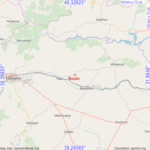
Bozan GPS coordinates[2]
39° 47' 17.016" North, 31° 6' 6.012" East
| Map corner | latitude | longitude |
|---|---|---|
| Upper-left | 40.32623°, | 30.39855° |
| Center: | 39.78806°, | 31.10167° |
| Lower-right: | 39.24565°, | 31.8048° |
| Map W x H: | 120.1×120.1 km | = 74.6×74.6mi |
| max Lat: | 42.02683° ⇑34.6% North |
| Bozan: | 39.78806° |
| min Lat: | ⇓65.4% South 35.9025° |
| min Long | Bozan | max Long |
| 25.90902° | 31.10167° | 44.60099° |
| W 29.8%⇐ | ⇒70.2% E |
Elevation
Elevation of Bozan is 806 m = 2644 ft, and this is 88.6 m = 291 ft above average elevation for this country.
| Max E: |
2682 m = 8799 ft | 44.1% |
| Bozan | 806 m 2644 ft | |
| Avg. | 717.4 m = 2354 ft | |
Min E: |
0 m = 0 ft | 55.9% |
See also: Turkey elevation on elevation.city.
Geographical zone
Bozan is located in North temperate zone (between Tropic of Cancer and the Arctic Circle). Distance of this Northern Tropic circle is 1818.1 km =1129.7 mi to South.| Distance of | km | miles | from Bozan |
|---|---|---|---|
| North Pole | 5583 | 3469.1 | to North |
| Arctic Circle | 2977.2 | 1849.9 | to North |
| Tropic Cancer | 1818.1 | 1129.7 | to South |
| Equator | 4424 | 2748.9 | to South |


Nearby cities:
15 places around Bozan: (largest is in red/bold)
• Alpu
12.2 km =7.6 mi,  260°
260°
• Beylikova
14.3 km =8.9 mi,  141°
141°
• Eskişehir
49.7 km =30.9 mi,  268°
268°
• Hekimdağ
47.8 km =29.7 mi,  286°
286°
• Kaymaz
30.9 km =19.2 mi,  167°
167°
• Mahmudiye
33.7 km =20.9 mi,  196°
196°
• Mihalgazi
52 km =32.3 mi,  300°
300°
• Mihalıçcık
34.7 km =21.6 mi,  75°
75°
• Nallıhan
49.1 km =30.5 mi,  25°
25°
• Odunpazarı
48.4 km =30.1 mi, 267°
• Sarıcakaya
49 km =30.4 mi, 304°
• Sevinç
35.3 km =21.9 mi, 268°
• Seyitgazi
51.7 km =32.1 mi,  222°
222°
• Tepebaşı
49.3 km =30.6 mi, 272°
• Çifteler
45.3 km =28.1 mi,  186°
186°
Sources, notices
• [Note1] Compared only with cities in Turkey existing in our database
• [Src1] Map data: © OpenStreetMap contributors (CC-BY-SA)
• [Src2] Other city data from geonames.org with taken over terms of usage.
• [Src3] Geographical zone / Annual Mean Temperature by Robert A. Rohde @ Wikipedia
