Bozüyük geodata
Bozüyük (Bilecik) is a seat of a second-order administrative division; located in Turkey in Europe/Istanbul (GMT+3) time zone. With population of 55,365 people, there are 159 cities with bigger population in this country. Compared to other cities in Turkey, 67.4% of cities are located further ↓South; 75.4% of cities are located further →East and 52.8% of cities have lower elevation than Bozüyük. Note1


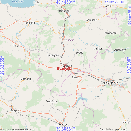
Bozüyük GPS coordinates[2]
39° 54' 28.008" North, 30° 2' 12.012" East
| Map corner | latitude | longitude |
|---|---|---|
| Upper-left | 40.44501°, | 29.33355° |
| Center: | 39.90778°, | 30.03667° |
| Lower-right: | 39.36631°, | 30.7398° |
| Map W x H: | 119.9×119.9 km | = 74.5×74.5mi |
| max Lat: | 42.02683° ⇑32.6% North |
| Bozüyük: | 39.90778° |
| min Lat: | ⇓67.4% South 35.9025° |
| min Long | Bozüyük | max Long |
| 25.90902° | 30.03667° | 44.60099° |
| W 24.6%⇐ | ⇒75.4% E |
Elevation
Elevation of Bozüyük is 752 m = 2467 ft, and this is 34.6 m = 114 ft above average elevation for this country.
| Max E: |
2682 m = 8799 ft | 47.2% |
| Bozüyük | 752 m 2467 ft | |
| Avg. | 717.4 m = 2354 ft | |
Min E: |
0 m = 0 ft | 52.8% |
See also: Bozüyük elevation on elevation.city.
Geographical zone
Bozüyük is located in North temperate zone (between Tropic of Cancer and the Arctic Circle). Distance of this Northern Tropic circle is 1831.4 km =1138 mi to South.| Distance of | km | miles | from Bozüyük |
|---|---|---|---|
| North Pole | 5569.7 | 3460.9 | to North |
| Arctic Circle | 2963.8 | 1841.6 | to North |
| Tropic Cancer | 1831.4 | 1138 | to South |
| Equator | 4437.3 | 2757.2 | to South |


Nearby cities:
15 places around Bozüyük: (largest is in red/bold)
• Bilecik
26.5 km =16.5 mi,  349°
349°
• Dodurga
15.8 km =9.8 mi,  220°
220°
• Domaniç
38.3 km =23.8 mi,  252°
252°
• Eskişehir
43.8 km =27.2 mi,  109°
109°
• Kurşunlu
35.2 km =21.9 mi,  294°
294°
• Küplü
21.4 km =13.3 mi, 351°
• Pazaryeri
14.8 km =9.2 mi,  310°
310°
• Sabuncu
40.6 km =25.2 mi,  161°
161°
• Söğüt
17.3 km =10.7 mi,  46°
46°
• Tahtaköprü
33.3 km =20.7 mi,  278°
278°
• Tepebaşı
43.1 km =26.8 mi,  104°
104°
• Vezirhan
37.5 km =23.3 mi,  357°
357°
• Yarhisar
37.1 km =23.1 mi,  337°
337°
• İnhisar
33.6 km =20.9 mi,  62°
62°
• İnönü
13.9 km =8.6 mi,  137°
137°
Sources, notices
• [Note1] Compared only with cities in Turkey existing in our database
• [Src1] Map data: © OpenStreetMap contributors (CC-BY-SA)
• [Src2] Other city data from geonames.org with taken over terms of usage.
• [Src3] Geographical zone / Annual Mean Temperature by Robert A. Rohde @ Wikipedia
