Günyüzü geodata
Günyüzü (Eskişehir) is a seat of a second-order administrative division; located in Turkey in Europe/Istanbul (GMT+3) time zone. In our database, there are 1323 cities with bigger population. Compared to other cities in Turkey, 59.8% of cities are located further ↓South; 67.6% of cities are located further →East and 60.6% of cities have lower elevation than Günyüzü. Note1


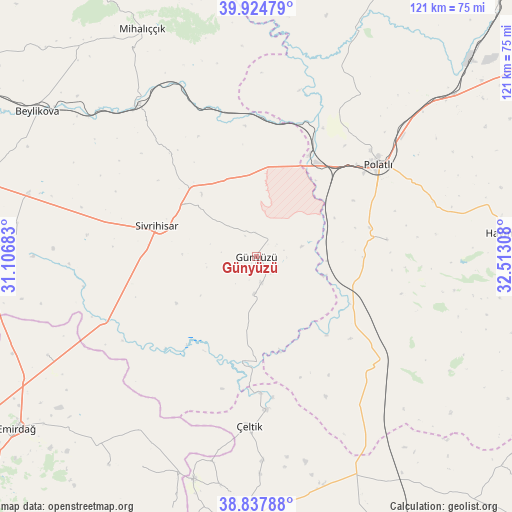
Günyüzü GPS coordinates[2]
39° 23' 0.42" North, 31° 48' 35.82" East
| Map corner | latitude | longitude |
|---|---|---|
| Upper-left | 39.92479°, | 31.10683° |
| Center: | 39.38345°, | 31.80995° |
| Lower-right: | 38.83788°, | 32.51308° |
| Map W x H: | 120.9×120.9 km | = 75.1×75.1mi |
| max Lat: | 42.02683° ⇑40.2% North |
| Günyüzü: | 39.38345° |
| min Lat: | ⇓59.8% South 35.9025° |
| min Long | Günyüzü | max Long |
| 25.90902° | 31.80995° | 44.60099° |
| W 32.4%⇐ | ⇒67.6% E |
Elevation
Elevation of Günyüzü is 892 m = 2927 ft, and this is 174.6 m = 573 ft above average elevation for this country.
| Max E: |
2682 m = 8799 ft | 39.4% |
| Günyüzü | 892 m 2927 ft | |
| Avg. | 717.4 m = 2354 ft | |
Min E: |
0 m = 0 ft | 60.6% |
See also: Turkey elevation on elevation.city.
Geographical zone
Günyüzü is located in North temperate zone (between Tropic of Cancer and the Arctic Circle). Distance of this Northern Tropic circle is 1773.1 km =1101.8 mi to South.| Distance of | km | miles | from Günyüzü |
|---|---|---|---|
| North Pole | 5628 | 3497.1 | to North |
| Arctic Circle | 3022.1 | 1877.8 | to North |
| Tropic Cancer | 1773.1 | 1101.8 | to South |
| Equator | 4379 | 2721 | to South |


Nearby cities:
15 places around Günyüzü: (largest is in red/bold)
• Beylikova
61.8 km =38.4 mi,  303°
303°
• Davulga
58.7 km =36.5 mi,  220°
220°
• Emirdağ
69.8 km =43.4 mi,  234°
234°
• Gelegra
70.1 km =43.6 mi,  1°
1°
• Haymana
59.3 km =36.8 mi,  84°
84°
• Kaymaz
56.1 km =34.9 mi,  285°
285°
• Mihalıçcık
60 km =37.3 mi,  333°
333°
• Polatlı
35.7 km =22.2 mi,  52°
52°
• Sivrihisar
24.8 km =15.4 mi, 287°
• Temelli
60.4 km =37.5 mi, 50°
• Umraniye
54.7 km =34 mi,  244°
244°
• Yenimehmetli
31.1 km =19.3 mi, 82°
• Yunak
63.7 km =39.6 mi,  186°
186°
• Çeltik
40 km =24.9 mi,  182°
182°
• Çifteler
66.2 km =41.1 mi,  269°
269°
Sources, notices
• [Note1] Compared only with cities in Turkey existing in our database
• [Src1] Map data: © OpenStreetMap contributors (CC-BY-SA)
• [Src2] Other city data from geonames.org with taken over terms of usage.
• [Src3] Geographical zone / Annual Mean Temperature by Robert A. Rohde @ Wikipedia
