Suvarlı geodata
Suvarlı (Adıyaman) is a seat of a third-order administrative division; located in Turkey in Europe/Istanbul (GMT+3) time zone. In our database, there are 1323 cities with bigger population. Compared to other cities in Turkey, 73.8% of cities are located further ↑North; 59.6% of cities are located further ←West and 66.4% of cities have lower elevation than Suvarlı. Note1


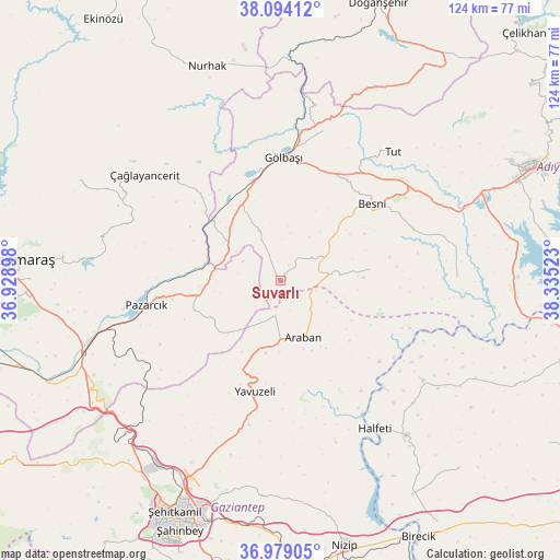
Suvarlı GPS coordinates[2]
37° 32' 19.212" North, 37° 37' 55.56" East
| Map corner | latitude | longitude |
|---|---|---|
| Upper-left | 38.09412°, | 36.92898° |
| Center: | 37.53867°, | 37.6321° |
| Lower-right: | 36.97905°, | 38.33523° |
| Map W x H: | 124×124 km | = 77.1×77.1mi |
| max Lat: | 42.02683° ⇑73.8% North |
| Suvarlı: | 37.53867° |
| min Lat: | ⇓26.2% South 35.9025° |
| min Long | Suvarlı | max Long |
| 25.90902° | 37.6321° | 44.60099° |
| W 59.6%⇐ | ⇒40.4% E |
Elevation
Elevation of Suvarlı is 979 m = 3212 ft, and this is 261.6 m = 858 ft above average elevation for this country.
| Max E: |
2682 m = 8799 ft | 33.6% |
| Suvarlı | 979 m 3212 ft | |
| Avg. | 717.4 m = 2354 ft | |
Min E: |
0 m = 0 ft | 66.4% |
See also: Turkey elevation on elevation.city.
Geographical zone
Suvarlı is located in North temperate zone (between Tropic of Cancer and the Arctic Circle). Distance of this Northern Tropic circle is 1568 km =974.3 mi to South.| Distance of | km | miles | from Suvarlı |
|---|---|---|---|
| North Pole | 5833.2 | 3624.6 | to North |
| Arctic Circle | 3227.3 | 2005.4 | to North |
| Tropic Cancer | 1568 | 974.3 | to South |
| Equator | 4173.9 | 2593.5 | to South |


Nearby cities:
15 places around Suvarlı: (largest is in red/bold)
• Araban
13.4 km =8.3 mi,  158°
158°
• Belören
11.9 km =7.4 mi,  337°
337°
• Besni
26.5 km =16.5 mi,  49°
49°
• Gölbaşı
27.2 km =16.9 mi,  0°
0°
• Halfeti
38.7 km =24 mi,  147°
147°
• Harmanlı
34.7 km =21.6 mi,  16°
16°
• Keysun
19.9 km =12.4 mi,  82°
82°
• Kızılin
39.1 km =24.3 mi,  88°
88°
• Narlı
46.7 km =29 mi,  249°
249°
• Nurhak
50.2 km =31.2 mi, 340°
• Pazarcık
29.9 km =18.6 mi,  258°
258°
• Tut
37.9 km =23.5 mi,  41°
41°
• Yavuzeli
25.2 km =15.7 mi,  192°
192°
• Çağlayancerit
38.1 km =23.7 mi,  307°
307°
• Şambayat
40 km =24.9 mi,  66°
66°
Sources, notices
• [Note1] Compared only with cities in Turkey existing in our database
• [Src1] Map data: © OpenStreetMap contributors (CC-BY-SA)
• [Src2] Other city data from geonames.org with taken over terms of usage.
• [Src3] Geographical zone / Annual Mean Temperature by Robert A. Rohde @ Wikipedia
