Sarıçam geodata
Sarıçam (Adana) is a seat of a second-order administrative division; located in Turkey in Europe/Istanbul (GMT+3) time zone. In our database, there are 1323 cities with bigger population. Compared to other cities in Turkey, 85.2% of cities are located further ↑North; 52.1% of cities are located further →East and 70% of cities have higher elevation than Sarıçam. Note1


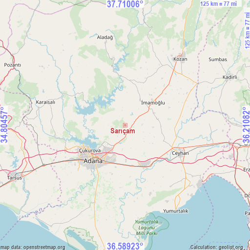
Sarıçam GPS coordinates[2]
37° 9' 6.192" North, 35° 30' 27.684" East
| Map corner | latitude | longitude |
|---|---|---|
| Upper-left | 37.71006°, | 34.80457° |
| Center: | 37.15172°, | 35.50769° |
| Lower-right: | 36.58923°, | 36.21082° |
| Map W x H: | 124.6×124.6 km | = 77.4×77.4mi |
| max Lat: | 42.02683° ⇑85.2% North |
| Sarıçam: | 37.15172° |
| min Lat: | ⇓14.8% South 35.9025° |
| min Long | Sarıçam | max Long |
| 25.90902° | 35.50769° | 44.60099° |
| W 47.9%⇐ | ⇒52.1% E |
Elevation
Elevation of Sarıçam is 303 m = 994 ft, and this is 414.4 m = 1360 ft below average elevation for this country.
| Max E: |
2682 m = 8799 ft | 70% |
| Avg. | 717.4 m = 2354 ft | |
| Sarıçam | 303 m = 994 ft | |
Min E: |
0 m = 0 ft | 30% |
See also: Turkey elevation on elevation.city.
Geographical zone
Sarıçam is located in North temperate zone (between Tropic of Cancer and the Arctic Circle). Distance of this Northern Tropic circle is 1525 km =947.6 mi to South.| Distance of | km | miles | from Sarıçam |
|---|---|---|---|
| North Pole | 5876.2 | 3651.3 | to North |
| Arctic Circle | 3270.3 | 2032.1 | to North |
| Tropic Cancer | 1525 | 947.6 | to South |
| Equator | 4130.9 | 2566.8 | to South |


Nearby cities:
15 places around Sarıçam: (largest is in red/bold)
• Adana
23 km =14.3 mi,  223°
223°
• Aladağ
45.2 km =28.1 mi,  347°
347°
• Ceyhan
30.9 km =19.2 mi,  117°
117°
• Doğankent
37.1 km =23.1 mi,  203°
203°
• Karaisalı
41.4 km =25.7 mi,  286°
286°
• Kozan
43.4 km =27 mi,  38°
38°
• Kösreli
41.7 km =25.9 mi,  88°
88°
• Sağkaya
16.3 km =10.1 mi,  79°
79°
• Seyhan
25.6 km =15.9 mi, 224°
• Tepecikören
25.6 km =15.9 mi,  24°
24°
• Yakapınar
22.2 km =13.8 mi,  153°
153°
• Yenice
44.8 km =27.8 mi,  244°
244°
• Yüreğir
23.7 km =14.7 mi,  213°
213°
• Çatalan
22 km =13.7 mi,  299°
299°
• İmamoğlu
18.3 km =11.4 mi,  46°
46°
Sources, notices
• [Note1] Compared only with cities in Turkey existing in our database
• [Src1] Map data: © OpenStreetMap contributors (CC-BY-SA)
• [Src2] Other city data from geonames.org with taken over terms of usage.
• [Src3] Geographical zone / Annual Mean Temperature by Robert A. Rohde @ Wikipedia
