Seyhan geodata
Seyhan (Adana) is a seat of a second-order administrative division; located in Turkey in Europe/Istanbul (GMT+3) time zone. In our database, there are 1323 cities with bigger population. Compared to other cities in Turkey, 88.2% of cities are located further ↑North; 53% of cities are located further →East and 93.4% of cities have higher elevation than Seyhan. Note1


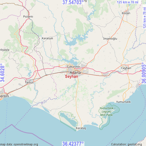
Seyhan GPS coordinates[2]
36° 59' 14.892" North, 35° 18' 21.312" East
| Map corner | latitude | longitude |
|---|---|---|
| Upper-left | 37.54703°, | 34.6028° |
| Center: | 36.98747°, | 35.30592° |
| Lower-right: | 36.42377°, | 36.00905° |
| Map W x H: | 124.9×124.9 km | = 77.6×77.6mi |
| max Lat: | 42.02683° ⇑88.2% North |
| Seyhan: | 36.98747° |
| min Lat: | ⇓11.8% South 35.9025° |
| min Long | Seyhan | max Long |
| 25.90902° | 35.30592° | 44.60099° |
| W 47%⇐ | ⇒53% E |
Elevation
Elevation of Seyhan is 23 m = 75 ft, and this is 694.4 m = 2278 ft below average elevation for this country.
| Max E: |
2682 m = 8799 ft | 93.4% |
| Avg. | 717.4 m = 2354 ft | |
| Seyhan | 23 m = 75 ft | |
Min E: |
0 m = 0 ft | 6.6% |
See also: Turkey elevation on elevation.city.
Geographical zone
Seyhan is located in North temperate zone (between Tropic of Cancer and the Arctic Circle). Distance of this Northern Tropic circle is 1506.7 km =936.2 mi to South.| Distance of | km | miles | from Seyhan |
|---|---|---|---|
| North Pole | 5894.4 | 3662.6 | to North |
| Arctic Circle | 3288.6 | 2043.4 | to North |
| Tropic Cancer | 1506.7 | 936.2 | to South |
| Equator | 4112.6 | 2555.5 | to South |


Nearby cities:
15 places around Seyhan: (largest is in red/bold)
• Adana
2.6 km =1.6 mi,  52°
52°
• Ceyhan
45.6 km =28.3 mi,  84°
84°
• Doğankent
16.3 km =10.1 mi,  168°
168°
• Karaisalı
37.1 km =23.1 mi,  323°
323°
• Karataş
45.4 km =28.2 mi, 172°
• Sarıçam
25.6 km =15.9 mi,  44°
44°
• Sağkaya
40 km =24.9 mi,  57°
57°
• Tarsus
37.5 km =23.3 mi,  258°
258°
• Tuzla
37.3 km =23.2 mi,  211°
211°
• Yakapınar
28 km =17.4 mi,  93°
93°
• Yenice
22.6 km =14 mi,  267°
267°
• Yumurtalık
49.4 km =30.7 mi,  119°
119°
• Yüreğir
4.9 km =3 mi,  107°
107°
• Çatalan
29.1 km =18.1 mi,  357°
357°
• İmamoğlu
43.8 km =27.2 mi, 45°
Sources, notices
• [Note1] Compared only with cities in Turkey existing in our database
• [Src1] Map data: © OpenStreetMap contributors (CC-BY-SA)
• [Src2] Other city data from geonames.org with taken over terms of usage.
• [Src3] Geographical zone / Annual Mean Temperature by Robert A. Rohde @ Wikipedia
