Karaisalı geodata
Karaisalı (Adana) is a seat of a second-order administrative division; located in Turkey in Europe/Istanbul (GMT+3) time zone. With population of 6,690 people, there are 626 cities with bigger population in this country. Compared to other cities in Turkey, 81.5% of cities are located further ↑North; 54% of cities are located further →East and 70.8% of cities have higher elevation than Karaisalı. Note1


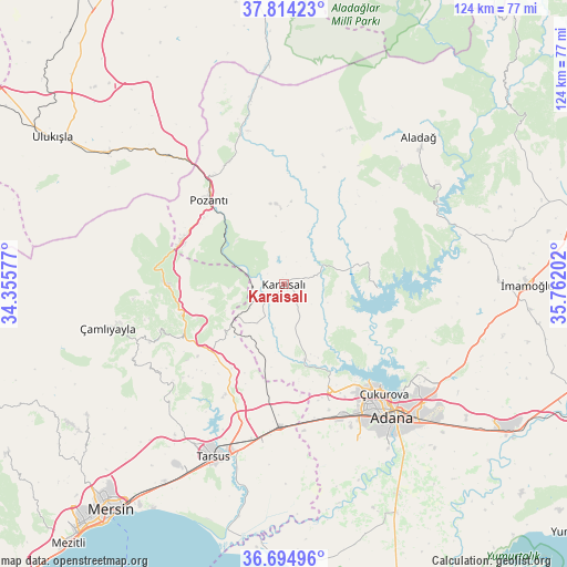
Karaisalı GPS coordinates[2]
37° 15' 24.012" North, 35° 3' 32.004" East
| Map corner | latitude | longitude |
|---|---|---|
| Upper-left | 37.81423°, | 34.35577° |
| Center: | 37.25667°, | 35.05889° |
| Lower-right: | 36.69496°, | 35.76202° |
| Map W x H: | 124.5×124.5 km | = 77.4×77.4mi |
| max Lat: | 42.02683° ⇑81.5% North |
| Karaisalı: | 37.25667° |
| min Lat: | ⇓18.5% South 35.9025° |
| min Long | Karaisalı | max Long |
| 25.90902° | 35.05889° | 44.60099° |
| W 46%⇐ | ⇒54% E |
Elevation
Elevation of Karaisalı is 271 m = 889 ft, and this is 446.4 m = 1465 ft below average elevation for this country.
| Max E: |
2682 m = 8799 ft | 70.8% |
| Avg. | 717.4 m = 2354 ft | |
| Karaisalı | 271 m = 889 ft | |
Min E: |
0 m = 0 ft | 29.2% |
See also: Turkey elevation on elevation.city.
Geographical zone
Karaisalı is located in North temperate zone (between Tropic of Cancer and the Arctic Circle). Distance of this Northern Tropic circle is 1536.6 km =954.8 mi to South.| Distance of | km | miles | from Karaisalı |
|---|---|---|---|
| North Pole | 5864.5 | 3644 | to North |
| Arctic Circle | 3258.6 | 2024.8 | to North |
| Tropic Cancer | 1536.6 | 954.8 | to South |
| Equator | 4142.6 | 2574.1 | to South |


Nearby cities:
15 places around Karaisalı: (largest is in red/bold)
• Adana
37.1 km =23.1 mi,  139°
139°
• Aladağ
44 km =27.3 mi,  42°
42°
• Doğankent
52.4 km =32.6 mi,  151°
151°
• Gözne
52 km =32.3 mi,  235°
235°
• Kamışlı
34.6 km =21.5 mi,  343°
343°
• Pozantı
25.2 km =15.7 mi,  318°
318°
• Sarıçam
41.4 km =25.7 mi,  106°
106°
• Seyhan
37.1 km =23.1 mi, 143°
• Tarsus
40.5 km =25.2 mi,  201°
201°
• Tepecikören
51.5 km =32 mi,  76°
76°
• Yenice
31.1 km =19.3 mi,  181°
181°
• Yüreğir
41.2 km =25.6 mi, 139°
• Çamlıyayla
42.5 km =26.4 mi,  256°
256°
• Çatalan
20.6 km =12.8 mi,  92°
92°
• Çiftehan
38.2 km =23.7 mi, 318°
Sources, notices
• [Note1] Compared only with cities in Turkey existing in our database
• [Src1] Map data: © OpenStreetMap contributors (CC-BY-SA)
• [Src2] Other city data from geonames.org with taken over terms of usage.
• [Src3] Geographical zone / Annual Mean Temperature by Robert A. Rohde @ Wikipedia
