Serinhisar geodata
Serinhisar (Denizli) is a seat of a second-order administrative division; located in Turkey in Europe/Istanbul (GMT+3) time zone. With population of 17,169 people, there are 361 cities with bigger population in this country. Compared to other cities in Turkey, 72.6% of cities are located further ↑North; 81.4% of cities are located further →East and 65% of cities have lower elevation than Serinhisar. Note1


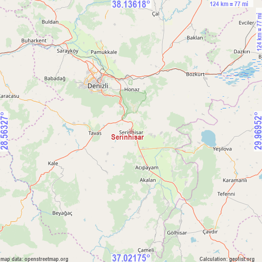
Serinhisar GPS coordinates[2]
37° 34' 51.78" North, 29° 15' 59.004" East
| Map corner | latitude | longitude |
|---|---|---|
| Upper-left | 38.13618°, | 28.56327° |
| Center: | 37.58105°, | 29.26639° |
| Lower-right: | 37.02175°, | 29.96952° |
| Map W x H: | 123.9×123.9 km | = 77×77mi |
| max Lat: | 42.02683° ⇑72.6% North |
| Serinhisar: | 37.58105° |
| min Lat: | ⇓27.4% South 35.9025° |
| min Long | Serinhisar | max Long |
| 25.90902° | 29.26639° | 44.60099° |
| W 18.6%⇐ | ⇒81.4% E |
Elevation
Elevation of Serinhisar is 958 m = 3143 ft, and this is 240.6 m = 789 ft above average elevation for this country.
| Max E: |
2682 m = 8799 ft | 35% |
| Serinhisar | 958 m 3143 ft | |
| Avg. | 717.4 m = 2354 ft | |
Min E: |
0 m = 0 ft | 65% |
See also: Turkey elevation on elevation.city.
Geographical zone
Serinhisar is located in North temperate zone (between Tropic of Cancer and the Arctic Circle). Distance of this Northern Tropic circle is 1572.7 km =977.2 mi to South.| Distance of | km | miles | from Serinhisar |
|---|---|---|---|
| North Pole | 5828.4 | 3621.6 | to North |
| Arctic Circle | 3222.6 | 2002.4 | to North |
| Tropic Cancer | 1572.7 | 977.2 | to South |
| Equator | 4178.6 | 2596.5 | to South |


Nearby cities:
15 places around Serinhisar: (largest is in red/bold)
• Acıpayam
19 km =11.8 mi,  157°
157°
• Babadağ
44 km =27.3 mi,  304°
304°
• Bozkurt
40.5 km =25.2 mi,  48°
48°
• Denizli
26.6 km =16.5 mi,  323°
323°
• Honaz
19.6 km =12.2 mi,  0°
0°
• Kale
40.4 km =25.1 mi,  246°
246°
• Kelekçi
38 km =23.6 mi,  174°
174°
• Kızılcabölük
22.1 km =13.7 mi,  278°
278°
• Merkezefendi
31.8 km =19.8 mi, 321°
• Nikfer
22.6 km =14 mi,  210°
210°
• Pamukkale
27.5 km =17.1 mi,  328°
328°
• Pamukkale
39.5 km =24.5 mi,  340°
340°
• Tavas
17.3 km =10.7 mi,  267°
267°
• Yeşilova
43.8 km =27.2 mi,  100°
100°
• Çardak
44.7 km =27.8 mi, 52°
Sources, notices
• [Note1] Compared only with cities in Turkey existing in our database
• [Src1] Map data: © OpenStreetMap contributors (CC-BY-SA)
• [Src2] Other city data from geonames.org with taken over terms of usage.
• [Src3] Geographical zone / Annual Mean Temperature by Robert A. Rohde @ Wikipedia
