Acıpayam geodata
Acıpayam (Denizli) is a seat of a second-order administrative division; located in Turkey in Europe/Istanbul (GMT+3) time zone. With population of 10,924 people, there are 488 cities with bigger population in this country. Compared to other cities in Turkey, 76.9% of cities are located further ↑North; 80.8% of cities are located further →East and 64.1% of cities have lower elevation than Acıpayam. Note1


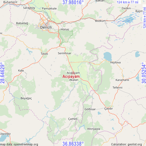
Acıpayam GPS coordinates[2]
37° 25' 25.86" North, 29° 20' 57.876" East
| Map corner | latitude | longitude |
|---|---|---|
| Upper-left | 37.98016°, | 28.64629° |
| Center: | 37.42385°, | 29.34941° |
| Lower-right: | 36.86338°, | 30.05254° |
| Map W x H: | 124.2×124.2 km | = 77.2×77.2mi |
| max Lat: | 42.02683° ⇑76.9% North |
| Acıpayam: | 37.42385° |
| min Lat: | ⇓23.1% South 35.9025° |
| min Long | Acıpayam | max Long |
| 25.90902° | 29.34941° | 44.60099° |
| W 19.2%⇐ | ⇒80.8% E |
Elevation
Elevation of Acıpayam is 947 m = 3107 ft, and this is 229.6 m = 753 ft above average elevation for this country.
| Max E: |
2682 m = 8799 ft | 35.9% |
| Acıpayam | 947 m 3107 ft | |
| Avg. | 717.4 m = 2354 ft | |
Min E: |
0 m = 0 ft | 64.1% |
See also: Turkey elevation on elevation.city.
Geographical zone
Acıpayam is located in North temperate zone (between Tropic of Cancer and the Arctic Circle). Distance of this Northern Tropic circle is 1555.2 km =966.4 mi to South.| Distance of | km | miles | from Acıpayam |
|---|---|---|---|
| North Pole | 5845.9 | 3632.5 | to North |
| Arctic Circle | 3240 | 2013.2 | to North |
| Tropic Cancer | 1555.2 | 966.4 | to South |
| Equator | 4161.1 | 2585.6 | to South |


Nearby cities:
15 places around Acıpayam: (largest is in red/bold)
• Beyağaç
45.2 km =28.1 mi,  242°
242°
• Denizli
45.3 km =28.1 mi,  329°
329°
• Gölhisar
34 km =21.1 mi,  155°
155°
• Honaz
37.7 km =23.4 mi,  349°
349°
• Kale
44.5 km =27.7 mi,  272°
272°
• Karamanlı
42.2 km =26.2 mi,  97°
97°
• Kelekçi
20.7 km =12.9 mi,  191°
191°
• Kızılcabölük
35.9 km =22.3 mi,  305°
305°
• Nikfer
18.8 km =11.7 mi,  263°
263°
• Serinhisar
19 km =11.8 mi,  337°
337°
• Tavas
29.7 km =18.5 mi,  304°
304°
• Tefenni
39.7 km =24.7 mi,  108°
108°
• Yeşilova
37 km =23 mi,  75°
75°
• Çameli
38.7 km =24 mi,  180°
180°
• Çavdır
42.7 km =26.5 mi,  134°
134°
Sources, notices
• [Note1] Compared only with cities in Turkey existing in our database
• [Src1] Map data: © OpenStreetMap contributors (CC-BY-SA)
• [Src2] Other city data from geonames.org with taken over terms of usage.
• [Src3] Geographical zone / Annual Mean Temperature by Robert A. Rohde @ Wikipedia
