Baykan geodata
Baykan (Siirt) is a seat of a second-order administrative division; located in Turkey in Europe/Istanbul (GMT+3) time zone. With population of 11,346 people, there are 470 cities with bigger population in this country. Compared to other cities in Turkey, 58.6% of cities are located further ↑North; 88.2% of cities are located further ←West and 52.1% of cities have lower elevation than Baykan. Note1


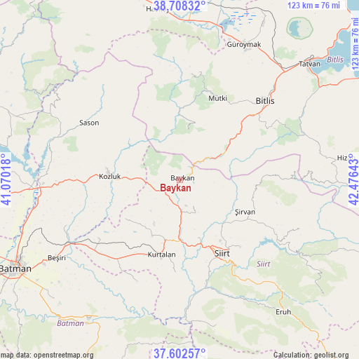
Baykan GPS coordinates[2]
38° 9' 27.144" North, 41° 46' 23.88" East
| Map corner | latitude | longitude |
|---|---|---|
| Upper-left | 38.70832°, | 41.07018° |
| Center: | 38.15754°, | 41.7733° |
| Lower-right: | 37.60257°, | 42.47643° |
| Map W x H: | 122.9×122.9 km | = 76.4×76.4mi |
| max Lat: | 42.02683° ⇑58.6% North |
| Baykan: | 38.15754° |
| min Lat: | ⇓41.4% South 35.9025° |
| min Long | Baykan | max Long |
| 25.90902° | 41.7733° | 44.60099° |
| W 88.2%⇐ | ⇒11.8% E |
Elevation
Elevation of Baykan is 743 m = 2438 ft, and this is 25.6 m = 84 ft above average elevation for this country.
| Max E: |
2682 m = 8799 ft | 47.9% |
| Baykan | 743 m 2438 ft | |
| Avg. | 717.4 m = 2354 ft | |
Min E: |
0 m = 0 ft | 52.1% |
See also: Turkey elevation on elevation.city.
Geographical zone
Baykan is located in North temperate zone (between Tropic of Cancer and the Arctic Circle). Distance of this Northern Tropic circle is 1636.8 km =1017.1 mi to South.| Distance of | km | miles | from Baykan |
|---|---|---|---|
| North Pole | 5764.3 | 3581.8 | to North |
| Arctic Circle | 3158.5 | 1962.6 | to North |
| Tropic Cancer | 1636.8 | 1017.1 | to South |
| Equator | 4242.7 | 2636.3 | to South |


Nearby cities:
15 places around Baykan: (largest is in red/bold)
• Aktaş
22.8 km =14.2 mi,  172°
172°
• Dilektepe
10.3 km =6.4 mi,  152°
152°
• Doluharman
22.9 km =14.2 mi, 146°
• Geyikpınar
18.3 km =11.4 mi,  13°
13°
• Kayabağlar
21.2 km =13.2 mi,  205°
205°
• Konakpınar
28.8 km =17.9 mi, 205°
• Kozluk
26.1 km =16.2 mi,  278°
278°
• Kurtalan
27 km =16.8 mi,  196°
196°
• Melefan
18.1 km =11.2 mi, 278°
• Meydan
22.1 km =13.7 mi,  359°
359°
• Narlıdere
12.8 km =8 mi,  52°
52°
• Sarıkonak
18.8 km =11.7 mi,  59°
59°
• Yanarsu
23.6 km =14.7 mi,  235°
235°
• İkizbağlar
26.5 km =16.5 mi,  138°
138°
• Şirvan
24.4 km =15.2 mi,  115°
115°
Sources, notices
• [Note1] Compared only with cities in Turkey existing in our database
• [Src1] Map data: © OpenStreetMap contributors (CC-BY-SA)
• [Src2] Other city data from geonames.org with taken over terms of usage.
• [Src3] Geographical zone / Annual Mean Temperature by Robert A. Rohde @ Wikipedia
