Şirvan geodata
Şirvan (Siirt) is a seat of a second-order administrative division; located in Turkey in Europe/Istanbul (GMT+3) time zone. With population of 5,510 people, there are 683 cities with bigger population in this country. Compared to other cities in Turkey, 60.3% of cities are located further ↑North; 90.6% of cities are located further ←West and 66.9% of cities have lower elevation than Şirvan. Note1


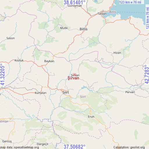
Şirvan GPS coordinates[2]
38° 3' 45.036" North, 42° 1' 30.612" East
| Map corner | latitude | longitude |
|---|---|---|
| Upper-left | 38.61401°, | 41.32205° |
| Center: | 38.06251°, | 42.02517° |
| Lower-right: | 37.50682°, | 42.7283° |
| Map W x H: | 123.1×123.1 km | = 76.5×76.5mi |
| max Lat: | 42.02683° ⇑60.3% North |
| Şirvan: | 38.06251° |
| min Lat: | ⇓39.7% South 35.9025° |
| min Long | Şirvan | max Long |
| 25.90902° | 42.02517° | 44.60099° |
| W 90.6%⇐ | ⇒9.4% E |
Elevation
Elevation of Şirvan is 985 m = 3232 ft, and this is 267.6 m = 878 ft above average elevation for this country.
| Max E: |
2682 m = 8799 ft | 33.1% |
| Şirvan | 985 m 3232 ft | |
| Avg. | 717.4 m = 2354 ft | |
Min E: |
0 m = 0 ft | 66.9% |
See also: Turkey elevation on elevation.city.
Geographical zone
Şirvan is located in North temperate zone (between Tropic of Cancer and the Arctic Circle). Distance of this Northern Tropic circle is 1626.2 km =1010.5 mi to South.| Distance of | km | miles | from Şirvan |
|---|---|---|---|
| North Pole | 5774.9 | 3588.4 | to North |
| Arctic Circle | 3169 | 1969.1 | to North |
| Tropic Cancer | 1626.2 | 1010.5 | to South |
| Equator | 4232.2 | 2629.8 | to South |


Nearby cities:
15 places around Şirvan: (largest is in red/bold)
• Aktaş
22.6 km =14 mi,  237°
237°
• Cevizlik
21.6 km =13.4 mi,  54°
54°
• Civankan
21.9 km =13.6 mi,  216°
216°
• Dilektepe
17.4 km =10.8 mi,  274°
274°
• Doluharman
12.8 km =8 mi,  228°
228°
• Durankaya
16 km =9.9 mi,  121°
121°
• Ekmekçiler
21.6 km =13.4 mi,  155°
155°
• Meydandere
16.5 km =10.3 mi, 157°
• Narlıdere
21.8 km =13.5 mi,  327°
327°
• Sarıkonak
20.9 km =13 mi,  344°
344°
• Siirt
16.5 km =10.3 mi,  206°
206°
• Taşlı
12.8 km =8 mi,  131°
131°
• Tillo
12.7 km =7.9 mi,  185°
185°
• Özpınar
20.2 km =12.6 mi,  108°
108°
• İkizbağlar
10.3 km =6.4 mi, 206°
Sources, notices
• [Note1] Compared only with cities in Turkey existing in our database
• [Src1] Map data: © OpenStreetMap contributors (CC-BY-SA)
• [Src2] Other city data from geonames.org with taken over terms of usage.
• [Src3] Geographical zone / Annual Mean Temperature by Robert A. Rohde @ Wikipedia
