Sason geodata
Sason (Batman) is a seat of a second-order administrative division; located in Turkey in Europe/Istanbul (GMT+3) time zone. With population of 11,403 people, there are 468 cities with bigger population in this country. Compared to other cities in Turkey, 55.5% of cities are located further ↑North; 85.6% of cities are located further ←West and 66.7% of cities have lower elevation than Sason. Note1


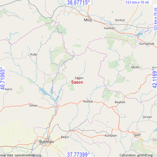
Sason GPS coordinates[2]
38° 19' 39.612" North, 41° 24' 49.572" East
| Map corner | latitude | longitude |
|---|---|---|
| Upper-left | 38.87715°, | 40.71065° |
| Center: | 38.32767°, | 41.41377° |
| Lower-right: | 37.77399°, | 42.1169° |
| Map W x H: | 122.7×122.7 km | = 76.2×76.2mi |
| max Lat: | 42.02683° ⇑55.5% North |
| Sason: | 38.32767° |
| min Lat: | ⇓44.5% South 35.9025° |
| min Long | Sason | max Long |
| 25.90902° | 41.41377° | 44.60099° |
| W 85.6%⇐ | ⇒14.4% E |
Elevation
Elevation of Sason is 981 m = 3219 ft, and this is 263.6 m = 865 ft above average elevation for this country.
| Max E: |
2682 m = 8799 ft | 33.3% |
| Sason | 981 m 3219 ft | |
| Avg. | 717.4 m = 2354 ft | |
Min E: |
0 m = 0 ft | 66.7% |
See also: Turkey elevation on elevation.city.
Geographical zone
Sason is located in North temperate zone (between Tropic of Cancer and the Arctic Circle). Distance of this Northern Tropic circle is 1655.7 km =1028.8 mi to South.| Distance of | km | miles | from Sason |
|---|---|---|---|
| North Pole | 5745.4 | 3570 | to North |
| Arctic Circle | 3139.5 | 1950.8 | to North |
| Tropic Cancer | 1655.7 | 1028.8 | to South |
| Equator | 4261.6 | 2648 | to South |


Nearby cities:
15 places around Sason: (largest is in red/bold)
• Akçasır
18.6 km =11.6 mi,  315°
315°
• Altınkum
31.5 km =19.6 mi,  256°
256°
• Baykan
36.7 km =22.8 mi,  121°
121°
• Bekirhan
23.3 km =14.5 mi,  206°
206°
• Beyçayırı
35.7 km =22.2 mi,  192°
192°
• Geyikpınar
35.5 km =22.1 mi,  91°
91°
• Hamzalı
22 km =13.7 mi,  274°
274°
• Kozluk
16.2 km =10.1 mi,  159°
159°
• Malabadi
26.9 km =16.7 mi,  223°
223°
• Melefan
21.3 km =13.2 mi,  140°
140°
• Meydan
31.2 km =19.4 mi,  84°
84°
• Saipbeyli
37.7 km =23.4 mi,  167°
167°
• Taliban
38.5 km =23.9 mi,  180°
180°
• Yanarsu
34.6 km =21.5 mi, 159°
• Yücebağ
14.7 km =9.1 mi,  299°
299°
Sources, notices
• [Note1] Compared only with cities in Turkey existing in our database
• [Src1] Map data: © OpenStreetMap contributors (CC-BY-SA)
• [Src2] Other city data from geonames.org with taken over terms of usage.
• [Src3] Geographical zone / Annual Mean Temperature by Robert A. Rohde @ Wikipedia
