Foça geodata
Foça (İzmir) is a seat of a second-order administrative division; located in Turkey in Europe/Istanbul (GMT+3) time zone. With population of 15,189 people, there are 389 cities with bigger population in this country. Compared to other cities in Turkey, 50.5% of cities are located further ↑North; 98.2% of cities are located further →East and 99.3% of cities have higher elevation than Foça. Note1


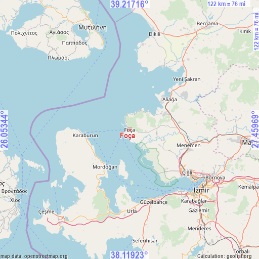
Foça GPS coordinates[2]
38° 40' 13.08" North, 26° 45' 23.616" East
| Map corner | latitude | longitude |
|---|---|---|
| Upper-left | 39.21716°, | 26.05344° |
| Center: | 38.6703°, | 26.75656° |
| Lower-right: | 38.11923°, | 27.45969° |
| Map W x H: | 122.1×122.1 km | = 75.9×75.9mi |
| max Lat: | 42.02683° ⇑50.5% North |
| Foça: | 38.6703° |
| min Lat: | ⇓49.5% South 35.9025° |
| min Long | Foça | max Long |
| 25.90902° | 26.75656° | 44.60099° |
| W 1.8%⇐ | ⇒98.2% E |
Elevation
Elevation of Foça is 5 m = 16 ft, and this is 712.4 m = 2337 ft below average elevation for this country.
| Max E: |
2682 m = 8799 ft | 99.3% |
| Avg. | 717.4 m = 2354 ft | |
| Foça | 5 m = 16 ft | |
Min E: |
0 m = 0 ft | 0.7% |
See also: Turkey elevation on elevation.city.
Geographical zone
Foça is located in North temperate zone (between Tropic of Cancer and the Arctic Circle). Distance of this Northern Tropic circle is 1693.8 km =1052.5 mi to South.| Distance of | km | miles | from Foça |
|---|---|---|---|
| North Pole | 5707.3 | 3546.4 | to North |
| Arctic Circle | 3101.4 | 1927.1 | to North |
| Tropic Cancer | 1693.8 | 1052.5 | to South |
| Equator | 4299.7 | 2671.7 | to South |


Nearby cities:
15 places around Foça: (largest is in red/bold)
• Aliağa
23.6 km =14.7 mi,  52°
52°
• Bayraklı
42 km =26.1 mi,  122°
122°
• Denizgiren
34 km =21.1 mi,  248°
248°
• Emiralem
34.5 km =21.4 mi,  101°
101°
• Karaburun
21.7 km =13.5 mi,  259°
259°
• Karşıyaka
38.8 km =24.1 mi,  127°
127°
• Menemen
28.1 km =17.5 mi, 104°
• Mordoğan
20.6 km =12.8 mi,  213°
213°
• Osmancalı
44.3 km =27.5 mi,  76°
76°
• Urla
38.6 km =24 mi,  179°
179°
• Yenifoça
9.7 km =6 mi,  43°
43°
• Yenişakran
36.1 km =22.4 mi, 48°
• Zeytindağ
42.9 km =26.7 mi, 39°
• Çandarlı
33.2 km =20.6 mi,  27°
27°
• İzmir
43.9 km =27.3 mi, 130°
Sources, notices
• [Note1] Compared only with cities in Turkey existing in our database
• [Src1] Map data: © OpenStreetMap contributors (CC-BY-SA)
• [Src2] Other city data from geonames.org with taken over terms of usage.
• [Src3] Geographical zone / Annual Mean Temperature by Robert A. Rohde @ Wikipedia
