Dinek geodata
Dinek (Konya) is a seat of a third-order administrative division; located in Turkey in Europe/Istanbul (GMT+3) time zone. In our database, there are 1323 cities with bigger population. Compared to other cities in Turkey, 79.6% of cities are located further ↑North; 64% of cities are located further →East and 80% of cities have lower elevation than Dinek. Note1


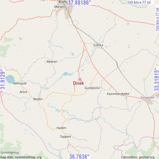
Dinek GPS coordinates[2]
37° 19' 29.316" North, 32° 36' 57.672" East
| Map corner | latitude | longitude |
|---|---|---|
| Upper-left | 37.88186°, | 31.9129° |
| Center: | 37.32481°, | 32.61602° |
| Lower-right: | 36.7636°, | 33.31915° |
| Map W x H: | 124.3×124.3 km | = 77.2×77.2mi |
| max Lat: | 42.02683° ⇑79.6% North |
| Dinek: | 37.32481° |
| min Lat: | ⇓20.4% South 35.9025° |
| min Long | Dinek | max Long |
| 25.90902° | 32.61602° | 44.60099° |
| W 36%⇐ | ⇒64% E |
Elevation
Elevation of Dinek is 1194 m = 3917 ft, and this is 476.6 m = 1564 ft above average elevation for this country.
| Max E: |
2682 m = 8799 ft | 20% |
| Dinek | 1194 m 3917 ft | |
| Avg. | 717.4 m = 2354 ft | |
Min E: |
0 m = 0 ft | 80% |
See also: Turkey elevation on elevation.city.
Geographical zone
Dinek is located in North temperate zone (between Tropic of Cancer and the Arctic Circle). Distance of this Northern Tropic circle is 1544.2 km =959.5 mi to South.| Distance of | km | miles | from Dinek |
|---|---|---|---|
| North Pole | 5856.9 | 3639.3 | to North |
| Arctic Circle | 3251 | 2020.1 | to North |
| Tropic Cancer | 1544.2 | 959.5 | to South |
| Equator | 4150.1 | 2578.8 | to South |


Nearby cities:
15 places around Dinek: (largest is in red/bold)
• Ahırlı
45 km =28 mi,  257°
257°
• Akören
26 km =16.2 mi,  303°
303°
• Belören
13.4 km =8.3 mi,  204°
204°
• Bozkır
35.9 km =22.3 mi,  245°
245°
• Güneysınır
11.7 km =7.3 mi,  121°
121°
• Hadim
40 km =24.9 mi, 200°
• Hatip
50.7 km =31.5 mi,  340°
340°
• Hatunsaray
37.6 km =23.4 mi,  321°
321°
• Kazımkarabekir
32.1 km =19.9 mi,  109°
109°
• Kılbasan
50.4 km =31.3 mi,  89°
89°
• Taşkent
45.9 km =28.5 mi,  193°
193°
• Yalıhüyük
47 km =29.2 mi,  266°
266°
• Çatalhöyük
42.5 km =26.4 mi,  25°
25°
• Çumra
31 km =19.3 mi, 26°
• Üçpınar
37.9 km =23.5 mi,  235°
235°
Sources, notices
• [Note1] Compared only with cities in Turkey existing in our database
• [Src1] Map data: © OpenStreetMap contributors (CC-BY-SA)
• [Src2] Other city data from geonames.org with taken over terms of usage.
• [Src3] Geographical zone / Annual Mean Temperature by Robert A. Rohde @ Wikipedia
