Hadim geodata
Hadim (Konya) is a seat of a second-order administrative division; located in Turkey in Europe/Istanbul (GMT+3) time zone. With population of 20,110 people, there are 329 cities with bigger population in this country. Compared to other cities in Turkey, 88.2% of cities are located further ↑North; 64.7% of cities are located further →East and 91.9% of cities have lower elevation than Hadim. Note1


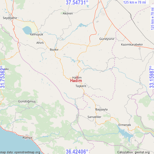
Hadim GPS coordinates[2]
36° 59' 15.936" North, 32° 27' 24.264" East
| Map corner | latitude | longitude |
|---|---|---|
| Upper-left | 37.54731°, | 31.75362° |
| Center: | 36.98776°, | 32.45674° |
| Lower-right: | 36.42406°, | 33.15987° |
| Map W x H: | 124.9×124.9 km | = 77.6×77.6mi |
| max Lat: | 42.02683° ⇑88.2% North |
| Hadim: | 36.98776° |
| min Lat: | ⇓11.8% South 35.9025° |
| min Long | Hadim | max Long |
| 25.90902° | 32.45674° | 44.60099° |
| W 35.3%⇐ | ⇒64.7% E |
Elevation
Elevation of Hadim is 1533 m = 5030 ft, and this is 815.6 m = 2676 ft above average elevation for this country.
| Max E: |
2682 m = 8799 ft | 8.1% |
| Hadim | 1533 m 5030 ft | |
| Avg. | 717.4 m = 2354 ft | |
Min E: |
0 m = 0 ft | 91.9% |
See also: Turkey elevation on elevation.city.
Geographical zone
Hadim is located in North temperate zone (between Tropic of Cancer and the Arctic Circle). Distance of this Northern Tropic circle is 1506.7 km =936.2 mi to South.| Distance of | km | miles | from Hadim |
|---|---|---|---|
| North Pole | 5894.4 | 3662.6 | to North |
| Arctic Circle | 3288.5 | 2043.4 | to North |
| Tropic Cancer | 1506.7 | 936.2 | to South |
| Equator | 4112.7 | 2555.5 | to South |


Nearby cities:
15 places around Hadim: (largest is in red/bold)
• Ahırlı
40.9 km =25.4 mi,  312°
312°
• Başyayla
32.8 km =20.4 mi,  142°
142°
• Belören
26.7 km =16.6 mi,  18°
18°
• Bozkır
29.1 km =18.1 mi,  320°
320°
• Bucakkışla
50.3 km =31.3 mi,  94°
94°
• Dinek
40 km =24.9 mi, 20°
• Eksere
45 km =28 mi,  244°
244°
• Göktepe
42.8 km =26.6 mi,  159°
159°
• Güneysınır
39.5 km =24.5 mi,  37°
37°
• Köprülü
37.3 km =23.2 mi,  220°
220°
• Sarıveliler
35.2 km =21.9 mi, 156°
• Taşkent
7.7 km =4.8 mi, 156°
• Tepebaşı
42.8 km =26.6 mi,  146°
146°
• Yalıhüyük
47.9 km =29.8 mi, 316°
• Üçpınar
23.8 km =14.8 mi, 313°
Sources, notices
• [Note1] Compared only with cities in Turkey existing in our database
• [Src1] Map data: © OpenStreetMap contributors (CC-BY-SA)
• [Src2] Other city data from geonames.org with taken over terms of usage.
• [Src3] Geographical zone / Annual Mean Temperature by Robert A. Rohde @ Wikipedia
