Taşkent geodata
Taşkent (Konya) is a seat of a second-order administrative division; located in Turkey in Europe/Istanbul (GMT+3) time zone. With population of 11,838 people, there are 454 cities with bigger population in this country. Compared to other cities in Turkey, 90.1% of cities are located further ↑North; 64.5% of cities are located further →East and 92.2% of cities have lower elevation than Taşkent. Note1


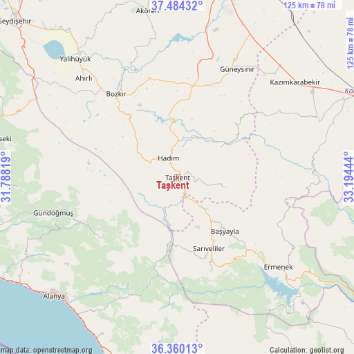
Taşkent GPS coordinates[2]
36° 55' 27.48" North, 32° 29' 28.716" East
| Map corner | latitude | longitude |
|---|---|---|
| Upper-left | 37.48432°, | 31.78819° |
| Center: | 36.9243°, | 32.49131° |
| Lower-right: | 36.36013°, | 33.19444° |
| Map W x H: | 125×125 km | = 77.7×77.7mi |
| max Lat: | 42.02683° ⇑90.1% North |
| Taşkent: | 36.9243° |
| min Lat: | ⇓9.9% South 35.9025° |
| min Long | Taşkent | max Long |
| 25.90902° | 32.49131° | 44.60099° |
| W 35.5%⇐ | ⇒64.5% E |
Elevation
Elevation of Taşkent is 1542 m = 5059 ft, and this is 824.6 m = 2705 ft above average elevation for this country.
| Max E: |
2682 m = 8799 ft | 7.8% |
| Taşkent | 1542 m 5059 ft | |
| Avg. | 717.4 m = 2354 ft | |
Min E: |
0 m = 0 ft | 92.2% |
See also: Turkey elevation on elevation.city.
Geographical zone
Taşkent is located in North temperate zone (between Tropic of Cancer and the Arctic Circle). Distance of this Northern Tropic circle is 1499.7 km =931.9 mi to South.| Distance of | km | miles | from Taşkent |
|---|---|---|---|
| North Pole | 5901.5 | 3667 | to North |
| Arctic Circle | 3295.6 | 2047.8 | to North |
| Tropic Cancer | 1499.7 | 931.9 | to South |
| Equator | 4105.6 | 2551.1 | to South |


Nearby cities:
15 places around Taşkent: (largest is in red/bold)
• Ahırlı
48.1 km =29.9 mi,  316°
316°
• Başyayla
25.4 km =15.8 mi,  138°
138°
• Belören
32.8 km =20.4 mi,  9°
9°
• Bozkır
36.6 km =22.7 mi, 323°
• Bucakkışla
47.3 km =29.4 mi,  85°
85°
• Dinek
45.9 km =28.5 mi, 13°
• Eksere
45.4 km =28.2 mi,  254°
254°
• Ermenek
47.6 km =29.6 mi,  131°
131°
• Göktepe
35.1 km =21.8 mi,  160°
160°
• Güneysınır
43.8 km =27.2 mi,  28°
28°
• Hadim
7.7 km =4.8 mi,  336°
336°
• Köprülü
34.6 km =21.5 mi,  231°
231°
• Sarıveliler
27.5 km =17.1 mi, 156°
• Tepebaşı
35.3 km =21.9 mi, 144°
• Üçpınar
31 km =19.3 mi, 318°
Sources, notices
• [Note1] Compared only with cities in Turkey existing in our database
• [Src1] Map data: © OpenStreetMap contributors (CC-BY-SA)
• [Src2] Other city data from geonames.org with taken over terms of usage.
• [Src3] Geographical zone / Annual Mean Temperature by Robert A. Rohde @ Wikipedia
