Çatalhöyük geodata
Çatalhöyük (Konya) is a populated place; located in Turkey in Europe/Istanbul (GMT+3) time zone. With population of 10,000 people, there are 510 cities with bigger population in this country. Compared to other cities in Turkey, 71.1% of cities are located further ↑North; 62.9% of cities are located further →East and 68.6% of cities have lower elevation than Çatalhöyük. Note1


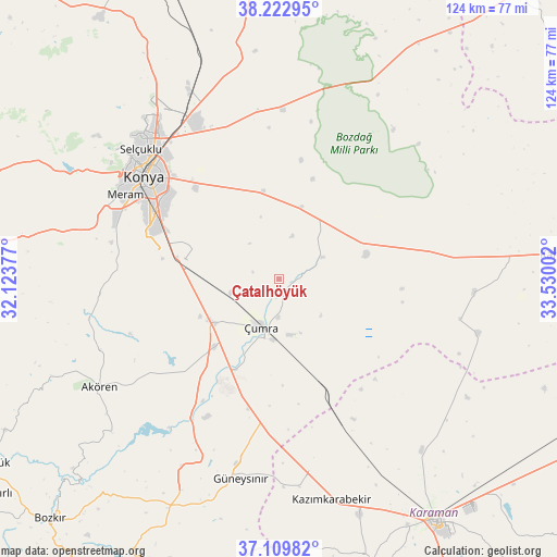
Çatalhöyük GPS coordinates[2]
37° 40' 6.492" North, 32° 49' 36.804" East
| Map corner | latitude | longitude |
|---|---|---|
| Upper-left | 38.22295°, | 32.12377° |
| Center: | 37.66847°, | 32.82689° |
| Lower-right: | 37.10982°, | 33.53002° |
| Map W x H: | 123.8×123.8 km | = 76.9×76.9mi |
| max Lat: | 42.02683° ⇑71.1% North |
| Çatalhöyük: | 37.66847° |
| min Lat: | ⇓28.9% South 35.9025° |
| min Long | Çatalhöyük | max Long |
| 25.90902° | 32.82689° | 44.60099° |
| W 37.1%⇐ | ⇒62.9% E |
Elevation
Elevation of Çatalhöyük is 1008 m = 3307 ft, and this is 290.6 m = 953 ft above average elevation for this country.
| Max E: |
2682 m = 8799 ft | 31.4% |
| Çatalhöyük | 1008 m 3307 ft | |
| Avg. | 717.4 m = 2354 ft | |
Min E: |
0 m = 0 ft | 68.6% |
See also: Turkey elevation on elevation.city.
Geographical zone
Çatalhöyük is located in North temperate zone (between Tropic of Cancer and the Arctic Circle). Distance of this Northern Tropic circle is 1582.4 km =983.3 mi to South.| Distance of | km | miles | from Çatalhöyük |
|---|---|---|---|
| North Pole | 5818.7 | 3615.6 | to North |
| Arctic Circle | 3212.8 | 1996.3 | to North |
| Tropic Cancer | 1582.4 | 983.3 | to South |
| Equator | 4188.3 | 2602.5 | to South |


Nearby cities:
15 places around Çatalhöyük: (largest is in red/bold)
• Akören
46.8 km =29.1 mi,  239°
239°
• Aşağıpınarbaşı
45.7 km =28.4 mi,  334°
334°
• Dinek
42.5 km =26.4 mi,  205°
205°
• Güneysınır
45.2 km =28.1 mi,  191°
191°
• Hatip
36.9 km =22.9 mi,  285°
285°
• Hatunsaray
43.1 km =26.8 mi,  257°
257°
• Hotamış
43.4 km =27 mi,  94°
94°
• Karatay
34.3 km =21.3 mi,  310°
310°
• Konya
37.6 km =23.4 mi, 306°
• Meram
36.3 km =22.6 mi,  299°
299°
• Ovakavağı
10.6 km =6.6 mi,  63°
63°
• Selçuklu
38 km =23.6 mi, 309°
• Sille
45.9 km =28.5 mi, 308°
• Yarma
16.6 km =10.3 mi,  17°
17°
• Çumra
11.6 km =7.2 mi,  203°
203°
Sources, notices
• [Note1] Compared only with cities in Turkey existing in our database
• [Src1] Map data: © OpenStreetMap contributors (CC-BY-SA)
• [Src2] Other city data from geonames.org with taken over terms of usage.
• [Src3] Geographical zone / Annual Mean Temperature by Robert A. Rohde @ Wikipedia
