Sarıoğlan geodata
Sarıoğlan (Kayseri) is a seat of a second-order administrative division; located in Turkey in Europe/Istanbul (GMT+3) time zone. With population of 5,393 people, there are 695 cities with bigger population in this country. Compared to other cities in Turkey, 55.5% of cities are located further ↓South; 50.1% of cities are located further →East and 78.5% of cities have lower elevation than Sarıoğlan. Note1


Sarıoğlan GPS coordinates[2]
39° 4' 36.984" North, 35° 58' 0.156" East
| Map corner | latitude | longitude |
|---|---|---|
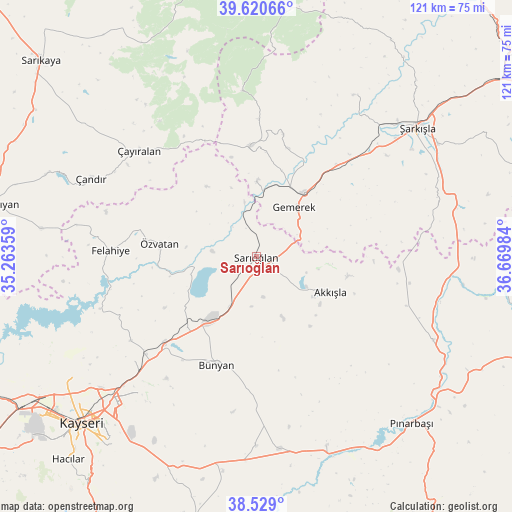
| Upper-left | 39.62066°, | 35.26359° |
| Center: | 39.07694°, | 35.96671° |
| Lower-right: | 38.529°, | 36.66984° |
| Map W x H: | 121.4×121.4 km | = 75.4×75.4mi |
| max Lat: | 42.02683° ⇑44.5% North |
| Sarıoğlan: | 39.07694° |
| min Lat: | ⇓55.5% South 35.9025° |
| min Long | Sarıoğlan | max Long |
| 25.90902° | 35.96671° | 44.60099° |
| W 49.9%⇐ | ⇒50.1% E |
Elevation
Elevation of Sarıoğlan is 1165 m = 3822 ft, and this is 447.6 m = 1469 ft above average elevation for this country.
| Max E: |
2682 m = 8799 ft | 21.5% |
| Sarıoğlan | 1165 m 3822 ft | |
| Avg. | 717.4 m = 2354 ft | |
Min E: |
0 m = 0 ft | 78.5% |
See also: Turkey elevation on elevation.city.
Geographical zone
Sarıoğlan is located in North temperate zone (between Tropic of Cancer and the Arctic Circle). Distance of this Northern Tropic circle is 1739 km =1080.6 mi to South.| Distance of | km | miles | from Sarıoğlan |
|---|---|---|---|
| North Pole | 5662.1 | 3518.3 | to North |
| Arctic Circle | 3056.2 | 1899 | to North |
| Tropic Cancer | 1739 | 1080.6 | to South |
| Equator | 4344.9 | 2699.8 | to South |


Nearby cities:
15 places around Sarıoğlan: (largest is in red/bold)
• Akkışla
19.7 km =12.2 mi,  114°
114°
• Bünyan
27.2 km =16.9 mi,  199°
199°
• Elbaşı
44.9 km =27.9 mi,  179°
179°
• Felahiye
34.5 km =21.4 mi,  272°
272°
• Gemerek
14.9 km =9.3 mi,  37°
37°
• Gesi
41.4 km =25.7 mi,  219°
219°
• Kaynar
46.5 km =28.9 mi,  115°
115°
• Kocasinan
48.1 km =29.9 mi,  225°
225°
• Muncusun
35.2 km =21.9 mi,  236°
236°
• Ortaköy
44.7 km =27.8 mi,  30°
30°
• Pazarören
47.8 km =29.7 mi,  159°
159°
• Çandır
43.2 km =26.8 mi,  295°
295°
• Çayıralan
37.5 km =23.3 mi,  312°
312°
• Özvatan
23.3 km =14.5 mi,  278°
278°
• Şarkışla
48.9 km =30.4 mi,  51°
51°
Sources, notices
• [Note1] Compared only with cities in Turkey existing in our database
• [Src1] Map data: © OpenStreetMap contributors (CC-BY-SA)
• [Src2] Other city data from geonames.org with taken over terms of usage.
• [Src3] Geographical zone / Annual Mean Temperature by Robert A. Rohde @ Wikipedia
