Ortaköy geodata
Ortaköy (Sivas) is a seat of a third-order administrative division; located in Turkey in Europe/Istanbul (GMT+3) time zone. In our database, there are 1323 cities with bigger population. Compared to other cities in Turkey, 60.2% of cities are located further ↓South; 52.8% of cities are located further ←West and 89% of cities have lower elevation than Ortaköy. Note1


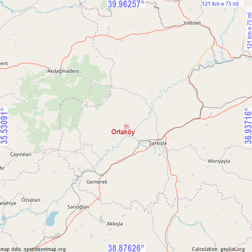
Ortaköy GPS coordinates[2]
39° 25' 17.508" North, 36° 14' 2.508" East
| Map corner | latitude | longitude |
|---|---|---|
| Upper-left | 39.96257°, | 35.53091° |
| Center: | 39.42153°, | 36.23403° |
| Lower-right: | 38.87626°, | 36.93716° |
| Map W x H: | 120.8×120.8 km | = 75.1×75.1mi |
| max Lat: | 42.02683° ⇑39.8% North |
| Ortaköy: | 39.42153° |
| min Lat: | ⇓60.2% South 35.9025° |
| min Long | Ortaköy | max Long |
| 25.90902° | 36.23403° | 44.60099° |
| W 52.8%⇐ | ⇒47.2% E |
Elevation
Elevation of Ortaköy is 1432 m = 4698 ft, and this is 714.6 m = 2344 ft above average elevation for this country.
| Max E: |
2682 m = 8799 ft | 11% |
| Ortaköy | 1432 m 4698 ft | |
| Avg. | 717.4 m = 2354 ft | |
Min E: |
0 m = 0 ft | 89% |
See also: Turkey elevation on elevation.city.
Geographical zone
Ortaköy is located in North temperate zone (between Tropic of Cancer and the Arctic Circle). Distance of this Northern Tropic circle is 1777.3 km =1104.4 mi to South.| Distance of | km | miles | from Ortaköy |
|---|---|---|---|
| North Pole | 5623.8 | 3494.5 | to North |
| Arctic Circle | 3017.9 | 1875.2 | to North |
| Tropic Cancer | 1777.3 | 1104.4 | to South |
| Equator | 4383.3 | 2723.7 | to South |


Nearby cities:
15 places around Ortaköy: (largest is in red/bold)
• Akcakışla
15.7 km =9.8 mi,  34°
34°
• Akdağmadeni
40.1 km =24.9 mi,  311°
311°
• Akkışla
46.9 km =29.1 mi,  186°
186°
• Altınyayla
47.4 km =29.5 mi,  110°
110°
• Bedirli
37.7 km =23.4 mi,  61°
61°
• Direkli
48.2 km =30 mi,  47°
47°
• Gemerek
29.9 km =18.6 mi,  207°
207°
• Kayadibi
41.6 km =25.8 mi,  81°
81°
• Sarıoğlan
44.7 km =27.8 mi, 210°
• Yavu
41.3 km =25.7 mi,  356°
356°
• Yıldızeli
58.5 km =36.4 mi, 32°
• Çayıralan
52.4 km =32.6 mi,  255°
255°
• Örenşehir
59.1 km =36.7 mi,  142°
142°
• Özvatan
57.8 km =35.9 mi,  232°
232°
• Şarkışla
17 km =10.6 mi,  117°
117°
Sources, notices
• [Note1] Compared only with cities in Turkey existing in our database
• [Src1] Map data: © OpenStreetMap contributors (CC-BY-SA)
• [Src2] Other city data from geonames.org with taken over terms of usage.
• [Src3] Geographical zone / Annual Mean Temperature by Robert A. Rohde @ Wikipedia
