Gökçeada geodata
Gökçeada (Canakkale) is a seat of a second-order administrative division; located in Turkey in Europe/Istanbul (GMT+3) time zone. With population of 7,822 people, there are 582 cities with bigger population in this country. Compared to other cities in Turkey, 72.6% of cities are located further ↓South; 100% of cities are located further →East and 86.5% of cities have higher elevation than Gökçeada. Note1


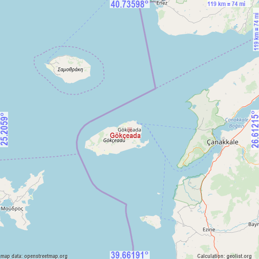
Gökçeada GPS coordinates[2]
40° 12' 3.852" North, 25° 54' 32.472" East
| Map corner | latitude | longitude |
|---|---|---|
| Upper-left | 40.73598°, | 25.2059° |
| Center: | 40.20107°, | 25.90902° |
| Lower-right: | 39.66191°, | 26.61215° |
| Map W x H: | 119.4×119.4 km | = 74.2×74.2mi |
| max Lat: | 42.02683° ⇑27.4% North |
| Gökçeada: | 40.20107° |
| min Lat: | ⇓72.6% South 35.9025° |
| min Long | Gökçeada | max Long |
| 25.90902° | 25.90902° | 44.60099° |
| W 0%⇐ | ⇒100% E |
Elevation
Elevation of Gökçeada is 63 m = 207 ft, and this is 654.4 m = 2147 ft below average elevation for this country.
| Max E: |
2682 m = 8799 ft | 86.5% |
| Avg. | 717.4 m = 2354 ft | |
| Gökçeada | 63 m = 207 ft | |
Min E: |
0 m = 0 ft | 13.5% |
See also: Turkey elevation on elevation.city.
Geographical zone
Gökçeada is located in North temperate zone (between Tropic of Cancer and the Arctic Circle). Distance of this Northern Tropic circle is 1864 km =1158.2 mi to South.| Distance of | km | miles | from Gökçeada |
|---|---|---|---|
| North Pole | 5537.1 | 3440.6 | to North |
| Arctic Circle | 2931.2 | 1821.4 | to North |
| Tropic Cancer | 1864 | 1158.2 | to South |
| Equator | 4469.9 | 2777.5 | to South |


Nearby cities:
15 places around Gökçeada: (largest is in red/bold)
• Bayramiç
73.9 km =45.9 mi,  126°
126°
• Bozcaada
42.9 km =26.7 mi,  161°
161°
• Eceabat
38.1 km =23.7 mi,  92°
92°
• Enez
60 km =37.3 mi,  14°
14°
• Ezine
59.1 km =36.7 mi,  141°
141°
• Gelibolu
68.7 km =42.7 mi,  70°
70°
• Geyikli
50.9 km =31.6 mi,  150°
150°
• Kirazlı
69.6 km =43.2 mi,  104°
104°
• Lapseki
67.8 km =42.1 mi,  76°
76°
• Mecidiye
72.2 km =44.9 mi,  47°
47°
• Merkez
44.2 km =27.5 mi, 100°
• Umurbey
59.3 km =36.8 mi, 86°
• Yiğitler
70.3 km =43.7 mi,  121°
121°
• Çanakkale
43.1 km =26.8 mi, 96°
• İntepe
41.7 km =25.9 mi, 120°
Sources, notices
• [Note1] Compared only with cities in Turkey existing in our database
• [Src1] Map data: © OpenStreetMap contributors (CC-BY-SA)
• [Src2] Other city data from geonames.org with taken over terms of usage.
• [Src3] Geographical zone / Annual Mean Temperature by Robert A. Rohde @ Wikipedia
