Bekirhan geodata
Bekirhan (Batman) is a seat of a third-order administrative division; located in Turkey in Europe/Istanbul (GMT+3) time zone. In our database, there are 1323 cities with bigger population. Compared to other cities in Turkey, 59.1% of cities are located further ↑North; 84.1% of cities are located further ←West and 52.4% of cities have higher elevation than Bekirhan. Note1


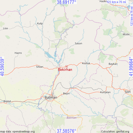
Bekirhan GPS coordinates[2]
38° 8' 27.096" North, 41° 17' 36.636" East
| Map corner | latitude | longitude |
|---|---|---|
| Upper-left | 38.69177°, | 40.59039° |
| Center: | 38.14086°, | 41.29351° |
| Lower-right: | 37.58576°, | 41.99664° |
| Map W x H: | 123×123 km | = 76.4×76.4mi |
| max Lat: | 42.02683° ⇑59.1% North |
| Bekirhan: | 38.14086° |
| min Lat: | ⇓40.9% South 35.9025° |
| min Long | Bekirhan | max Long |
| 25.90902° | 41.29351° | 44.60099° |
| W 84.1%⇐ | ⇒15.9% E |
Elevation
Elevation of Bekirhan is 645 m = 2116 ft, and this is 72.4 m = 238 ft below average elevation for this country.
| Max E: |
2682 m = 8799 ft | 52.4% |
| Avg. | 717.4 m = 2354 ft | |
| Bekirhan | 645 m = 2116 ft | |
Min E: |
0 m = 0 ft | 47.6% |
See also: Turkey elevation on elevation.city.
Geographical zone
Bekirhan is located in North temperate zone (between Tropic of Cancer and the Arctic Circle). Distance of this Northern Tropic circle is 1634.9 km =1015.9 mi to South.| Distance of | km | miles | from Bekirhan |
|---|---|---|---|
| North Pole | 5766.2 | 3582.9 | to North |
| Arctic Circle | 3160.3 | 1963.7 | to North |
| Tropic Cancer | 1634.9 | 1015.9 | to South |
| Equator | 4240.9 | 2635.2 | to South |


Nearby cities:
15 places around Bekirhan: (largest is in red/bold)
• Altınkum
24.4 km =15.2 mi,  304°
304°
• Aviski
19.9 km =12.4 mi,  170°
170°
• Beyçayırı
14.3 km =8.9 mi, 169°
• Beşiri
25 km =15.5 mi,  181°
181°
• Demirlipınar
22.4 km =13.9 mi,  207°
207°
• Doğankavak
20.7 km =12.9 mi,  196°
196°
• Gökdoğan
23 km =14.3 mi,  155°
155°
• Gözpınar
23.2 km =14.4 mi,  141°
141°
• Kozluk
17.1 km =10.6 mi,  70°
70°
• Malabadi
8 km =5 mi,  278°
278°
• Melefan
24.5 km =15.2 mi,  79°
79°
• Saipbeyli
24.8 km =15.4 mi,  129°
129°
• Sason
23.3 km =14.5 mi,  26°
26°
• Silvan
25 km =15.5 mi,  269°
269°
• Taliban
20.6 km =12.8 mi,  149°
149°
Sources, notices
• [Note1] Compared only with cities in Turkey existing in our database
• [Src1] Map data: © OpenStreetMap contributors (CC-BY-SA)
• [Src2] Other city data from geonames.org with taken over terms of usage.
• [Src3] Geographical zone / Annual Mean Temperature by Robert A. Rohde @ Wikipedia
