Malabadi geodata
Malabadi (Diyarbakır) is a seat of a third-order administrative division; located in Turkey in Europe/Istanbul (GMT+3) time zone. In our database, there are 1323 cities with bigger population. Compared to other cities in Turkey, 58.9% of cities are located further ↑North; 83% of cities are located further ←West and 53.9% of cities have higher elevation than Malabadi. Note1


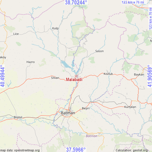
Malabadi GPS coordinates[2]
38° 9' 5.832" North, 41° 12' 9.216" East
| Map corner | latitude | longitude |
|---|---|---|
| Upper-left | 38.70244°, | 40.49944° |
| Center: | 38.15162°, | 41.20256° |
| Lower-right: | 37.5966°, | 41.90569° |
| Map W x H: | 123×123 km | = 76.4×76.4mi |
| max Lat: | 42.02683° ⇑58.9% North |
| Malabadi: | 38.15162° |
| min Lat: | ⇓41.1% South 35.9025° |
| min Long | Malabadi | max Long |
| 25.90902° | 41.20256° | 44.60099° |
| W 83%⇐ | ⇒17% E |
Elevation
Elevation of Malabadi is 613 m = 2011 ft, and this is 104.4 m = 343 ft below average elevation for this country.
| Max E: |
2682 m = 8799 ft | 53.9% |
| Avg. | 717.4 m = 2354 ft | |
| Malabadi | 613 m = 2011 ft | |
Min E: |
0 m = 0 ft | 46.1% |
See also: Turkey elevation on elevation.city.
Geographical zone
Malabadi is located in North temperate zone (between Tropic of Cancer and the Arctic Circle). Distance of this Northern Tropic circle is 1636.1 km =1016.6 mi to South.| Distance of | km | miles | from Malabadi |
|---|---|---|---|
| North Pole | 5765 | 3582.2 | to North |
| Arctic Circle | 3159.1 | 1963 | to North |
| Tropic Cancer | 1636.1 | 1016.6 | to South |
| Equator | 4242.1 | 2635.9 | to South |


Nearby cities:
15 places around Malabadi: (largest is in red/bold)
• Akbaş
23.1 km =14.4 mi,  212°
212°
• Akoba
26.5 km =16.5 mi, 209°
• Akçayır
25.8 km =16 mi,  226°
226°
• Altınkum
17.5 km =10.9 mi,  315°
315°
• Aviski
23.6 km =14.7 mi,  151°
151°
• Bekirhan
8 km =5 mi,  98°
98°
• Beyçayırı
18.6 km =11.6 mi, 145°
• Demirlipınar
21.3 km =13.2 mi,  186°
186°
• Demiryol
26.4 km =16.4 mi, 190°
• Doğankavak
21.1 km =13.1 mi,  174°
174°
• Hamzalı
21.4 km =13.3 mi,  350°
350°
• Kozluk
24.5 km =15.2 mi,  79°
79°
• Sason
26.9 km =16.7 mi,  43°
43°
• Silvan
17.1 km =10.6 mi,  264°
264°
• Taliban
26.5 km =16.5 mi,  135°
135°
Sources, notices
• [Note1] Compared only with cities in Turkey existing in our database
• [Src1] Map data: © OpenStreetMap contributors (CC-BY-SA)
• [Src2] Other city data from geonames.org with taken over terms of usage.
• [Src3] Geographical zone / Annual Mean Temperature by Robert A. Rohde @ Wikipedia
