Silvan geodata
Silvan (Diyarbakır) is a seat of a second-order administrative division; located in Turkey in Europe/Istanbul (GMT+3) time zone. With population of 65,956 people, there are 140 cities with bigger population in this country. Compared to other cities in Turkey, 59.1% of cities are located further ↑North; 81.6% of cities are located further ←West and 56% of cities have lower elevation than Silvan. Note1


Silvan GPS coordinates[2]
38° 8' 13.488" North, 41° 0' 29.412" East
| Map corner | latitude | longitude |
|---|---|---|
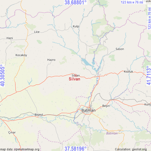
| Upper-left | 38.68801°, | 40.30505° |
| Center: | 38.13708°, | 41.00817° |
| Lower-right: | 37.58196°, | 41.7113° |
| Map W x H: | 123×123 km | = 76.4×76.4mi |
| max Lat: | 42.02683° ⇑59.1% North |
| Silvan: | 38.13708° |
| min Lat: | ⇓40.9% South 35.9025° |
| min Long | Silvan | max Long |
| 25.90902° | 41.00817° | 44.60099° |
| W 81.6%⇐ | ⇒18.4% E |
Elevation
Elevation of Silvan is 810 m = 2657 ft, and this is 92.6 m = 304 ft above average elevation for this country.
| Max E: |
2682 m = 8799 ft | 44% |
| Silvan | 810 m 2657 ft | |
| Avg. | 717.4 m = 2354 ft | |
Min E: |
0 m = 0 ft | 56% |
See also: Silvan elevation on elevation.city.
Geographical zone
Silvan is located in North temperate zone (between Tropic of Cancer and the Arctic Circle). Distance of this Northern Tropic circle is 1634.5 km =1015.6 mi to South.| Distance of | km | miles | from Silvan |
|---|---|---|---|
| North Pole | 5766.6 | 3583.2 | to North |
| Arctic Circle | 3160.7 | 1964 | to North |
| Tropic Cancer | 1634.5 | 1015.6 | to South |
| Equator | 4240.4 | 2634.9 | to South |


Nearby cities:
15 places around Silvan: (largest is in red/bold)
• Akbaş
18.3 km =11.4 mi,  165°
165°
• Akoba
21.9 km =13.6 mi, 169°
• Akçayır
16.3 km =10.1 mi,  185°
185°
• Altınkum
14.9 km =9.3 mi,  18°
18°
• Bademli
23.9 km =14.9 mi, 189°
• Bağdere
24.1 km =15 mi,  264°
264°
• Bekirhan
25 km =15.5 mi,  89°
89°
• Demirlipınar
24.4 km =15.2 mi,  143°
143°
• Diktepe
24.6 km =15.3 mi, 169°
• Doğankavak
27.2 km =16.9 mi, 135°
• Güngeçti
27.1 km =16.8 mi,  197°
197°
• Hamzalı
26.4 km =16.4 mi,  30°
30°
• Hazro
24.2 km =15 mi,  301°
301°
• Kopuzlu
20.9 km =13 mi, 191°
• Malabadi
17.1 km =10.6 mi,  84°
84°
Sources, notices
• [Note1] Compared only with cities in Turkey existing in our database
• [Src1] Map data: © OpenStreetMap contributors (CC-BY-SA)
• [Src2] Other city data from geonames.org with taken over terms of usage.
• [Src3] Geographical zone / Annual Mean Temperature by Robert A. Rohde @ Wikipedia
