Civankan geodata
Civankan (Siirt) is a populated place; located in Turkey in Europe/Istanbul (GMT+3) time zone. With population of 2,583 people, there are 895 cities with bigger population in this country. Compared to other cities in Turkey, 64.8% of cities are located further ↑North; 89.3% of cities are located further ←West and 62.9% of cities have lower elevation than Civankan. Note1


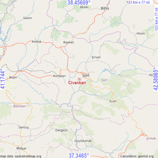
Civankan GPS coordinates[2]
37° 54' 12.204" North, 41° 52' 39.072" East
| Map corner | latitude | longitude |
|---|---|---|
| Upper-left | 38.45609°, | 41.1744° |
| Center: | 37.90339°, | 41.87752° |
| Lower-right: | 37.3465°, | 42.58065° |
| Map W x H: | 123.4×123.4 km | = 76.7×76.7mi |
| max Lat: | 42.02683° ⇑64.8% North |
| Civankan: | 37.90339° |
| min Lat: | ⇓35.2% South 35.9025° |
| min Long | Civankan | max Long |
| 25.90902° | 41.87752° | 44.60099° |
| W 89.3%⇐ | ⇒10.7% E |
Elevation
Elevation of Civankan is 928 m = 3045 ft, and this is 210.6 m = 691 ft above average elevation for this country.
| Max E: |
2682 m = 8799 ft | 37.1% |
| Civankan | 928 m 3045 ft | |
| Avg. | 717.4 m = 2354 ft | |
Min E: |
0 m = 0 ft | 62.9% |
See also: Turkey elevation on elevation.city.
Geographical zone
Civankan is located in North temperate zone (between Tropic of Cancer and the Arctic Circle). Distance of this Northern Tropic circle is 1608.5 km =999.5 mi to South.| Distance of | km | miles | from Civankan |
|---|---|---|---|
| North Pole | 5792.6 | 3599.4 | to North |
| Arctic Circle | 3186.7 | 1980.1 | to North |
| Tropic Cancer | 1608.5 | 999.5 | to South |
| Equator | 4214.5 | 2618.8 | to South |


Nearby cities:
15 places around Civankan: (largest is in red/bold)
• Aktaş
8.4 km =5.2 mi,  312°
312°
• Bağlıca
11.7 km =7.3 mi,  251°
251°
• Beykent
16.9 km =10.5 mi,  262°
262°
• Dilektepe
19.6 km =12.2 mi,  346°
346°
• Doluharman
9.7 km =6 mi,  20°
20°
• Ekmekçiler
22 km =13.7 mi,  95°
95°
• Kayabağlar
20.6 km =12.8 mi,  296°
296°
• Konakpınar
21.6 km =13.4 mi,  276°
276°
• Kurtalan
17.1 km =10.6 mi, 278°
• Lodi
21.5 km =13.4 mi,  171°
171°
• Meydandere
19.4 km =12.1 mi,  82°
82°
• Siirt
6.3 km =3.9 mi,  62°
62°
• Tillo
12.9 km =8 mi,  66°
66°
• İkizbağlar
11.9 km =7.4 mi,  44°
44°
• Şirvan
21.9 km =13.6 mi, 36°
Sources, notices
• [Note1] Compared only with cities in Turkey existing in our database
• [Src1] Map data: © OpenStreetMap contributors (CC-BY-SA)
• [Src2] Other city data from geonames.org with taken over terms of usage.
• [Src3] Geographical zone / Annual Mean Temperature by Robert A. Rohde @ Wikipedia
