Siirt geodata
Siirt is a seat of a first-order administrative division; located in Turkey in Europe/Istanbul (GMT+3) time zone. With population of 114,034 people, there are 75 cities with bigger population in this country. Compared to other cities in Turkey, 63.5% of cities are located further ↑North; 89.9% of cities are located further ←West and 60.7% of cities have lower elevation than Siirt. Note1


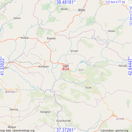
Siirt GPS coordinates[2]
37° 55' 45.48" North, 41° 56' 28.824" East
| Map corner | latitude | longitude |
|---|---|---|
| Upper-left | 38.48181°, | 41.23822° |
| Center: | 37.9293°, | 41.94134° |
| Lower-right: | 37.37261°, | 42.64447° |
| Map W x H: | 123.3×123.3 km | = 76.6×76.6mi |
| max Lat: | 42.02683° ⇑63.5% North |
| Siirt: | 37.9293° |
| min Lat: | ⇓36.5% South 35.9025° |
| min Long | Siirt | max Long |
| 25.90902° | 41.94134° | 44.60099° |
| W 89.9%⇐ | ⇒10.1% E |
Elevation
Elevation of Siirt is 893 m = 2930 ft, and this is 175.6 m = 576 ft above average elevation for this country.
| Max E: |
2682 m = 8799 ft | 39.3% |
| Siirt | 893 m 2930 ft | |
| Avg. | 717.4 m = 2354 ft | |
Min E: |
0 m = 0 ft | 60.7% |
See also: Siirt elevation on elevation.city.
Geographical zone
Siirt is located in North temperate zone (between Tropic of Cancer and the Arctic Circle). Distance of this Northern Tropic circle is 1611.4 km =1001.3 mi to South.| Distance of | km | miles | from Siirt |
|---|---|---|---|
| North Pole | 5789.7 | 3597.6 | to North |
| Arctic Circle | 3183.8 | 1978.3 | to North |
| Tropic Cancer | 1611.4 | 1001.3 | to South |
| Equator | 4217.3 | 2620.5 | to South |


Nearby cities:
15 places around Siirt: (largest is in red/bold)
• Aktaş
12.1 km =7.5 mi,  282°
282°
• Bağlıca
18 km =11.2 mi,  248°
248°
• Beykent
22.9 km =14.2 mi,  257°
257°
• Civankan
6.3 km =3.9 mi,  242°
242°
• Dilektepe
19.1 km =11.9 mi,  328°
328°
• Doluharman
6.6 km =4.1 mi,  340°
340°
• Durankaya
21.9 km =13.6 mi,  73°
73°
• Ekmekçiler
17 km =10.6 mi,  106°
106°
• Kurtalan
22.5 km =14 mi,  268°
268°
• Meydandere
13.6 km =8.5 mi,  91°
91°
• Palamutlu
23.2 km =14.4 mi,  99°
99°
• Taşlı
18.2 km =11.3 mi, 69°
• Tillo
6.6 km =4.1 mi, 70°
• İkizbağlar
6.2 km =3.9 mi,  26°
26°
• Şirvan
16.5 km =10.3 mi, 26°
Sources, notices
• [Note1] Compared only with cities in Turkey existing in our database
• [Src1] Map data: © OpenStreetMap contributors (CC-BY-SA)
• [Src2] Other city data from geonames.org with taken over terms of usage.
• [Src3] Geographical zone / Annual Mean Temperature by Robert A. Rohde @ Wikipedia
