Akarsu geodata
Akarsu (Erzincan) is a seat of a third-order administrative division; located in Turkey in Europe/Istanbul (GMT+3) time zone. In our database, there are 1323 cities with bigger population. Compared to other cities in Turkey, 68.1% of cities are located further ↓South; 64.8% of cities are located further ←West and 91.7% of cities have lower elevation than Akarsu. Note1


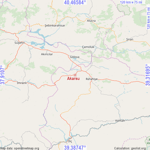
Akarsu GPS coordinates[2]
39° 55' 43.608" North, 38° 36' 49.752" East
| Map corner | latitude | longitude |
|---|---|---|
| Upper-left | 40.46584°, | 37.9107° |
| Center: | 39.92878°, | 38.61382° |
| Lower-right: | 39.38747°, | 39.31695° |
| Map W x H: | 119.9×119.9 km | = 74.5×74.5mi |
| max Lat: | 42.02683° ⇑31.9% North |
| Akarsu: | 39.92878° |
| min Lat: | ⇓68.1% South 35.9025° |
| min Long | Akarsu | max Long |
| 25.90902° | 38.61382° | 44.60099° |
| W 64.8%⇐ | ⇒35.2% E |
Elevation
Elevation of Akarsu is 1531 m = 5023 ft, and this is 813.6 m = 2669 ft above average elevation for this country.
| Max E: |
2682 m = 8799 ft | 8.3% |
| Akarsu | 1531 m 5023 ft | |
| Avg. | 717.4 m = 2354 ft | |
Min E: |
0 m = 0 ft | 91.7% |
See also: Turkey elevation on elevation.city.
Geographical zone
Akarsu is located in North temperate zone (between Tropic of Cancer and the Arctic Circle). Distance of this Northern Tropic circle is 1833.7 km =1139.4 mi to South.| Distance of | km | miles | from Akarsu |
|---|---|---|---|
| North Pole | 5567.4 | 3459.4 | to North |
| Arctic Circle | 2961.5 | 1840.2 | to North |
| Tropic Cancer | 1833.7 | 1139.4 | to South |
| Equator | 4439.7 | 2758.7 | to South |


Nearby cities:
15 places around Akarsu: (largest is in red/bold)
• Akıncılar
28 km =17.4 mi,  304°
304°
• Alucra
44.7 km =27.8 mi,  15°
15°
• Armutlu
42.4 km =26.3 mi,  202°
202°
• Bozoğlak
37.6 km =23.4 mi,  154°
154°
• Cengerli
25 km =15.5 mi,  126°
126°
• Doğanbeyli
44.4 km =27.6 mi, 125°
• Gölova
14.8 km =9.2 mi,  357°
357°
• Gümüşakar
15.8 km =9.8 mi,  161°
161°
• Karacaören
47.9 km =29.8 mi,  242°
242°
• Kuruçay
34.2 km =21.3 mi, 200°
• Refahiye
13.6 km =8.5 mi,  106°
106°
• Çamoluk
24.2 km =15 mi, 24°
• Çatalçam
20.6 km =12.8 mi,  75°
75°
• İmranlı
43.1 km =26.8 mi,  262°
262°
• Şebin Karahisar
43.1 km =26.8 mi,  337°
337°
Sources, notices
• [Note1] Compared only with cities in Turkey existing in our database
• [Src1] Map data: © OpenStreetMap contributors (CC-BY-SA)
• [Src2] Other city data from geonames.org with taken over terms of usage.
• [Src3] Geographical zone / Annual Mean Temperature by Robert A. Rohde @ Wikipedia
