Alucra geodata
Alucra (Giresun) is a seat of a second-order administrative division; located in Turkey in Europe/Istanbul (GMT+3) time zone. In our database, there are 1323 cities with bigger population. Compared to other cities in Turkey, 74.6% of cities are located further ↓South; 65.5% of cities are located further ←West and 95.7% of cities have lower elevation than Alucra. Note1


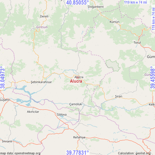
Alucra GPS coordinates[2]
40° 18' 59.616" North, 38° 45' 10.26" East
| Map corner | latitude | longitude |
|---|---|---|
| Upper-left | 40.85055°, | 38.04973° |
| Center: | 40.31656°, | 38.75285° |
| Lower-right: | 39.77831°, | 39.45598° |
| Map W x H: | 119.2×119.2 km | = 74.1×74.1mi |
| max Lat: | 42.02683° ⇑25.4% North |
| Alucra: | 40.31656° |
| min Lat: | ⇓74.6% South 35.9025° |
| min Long | Alucra | max Long |
| 25.90902° | 38.75285° | 44.60099° |
| W 65.5%⇐ | ⇒34.5% E |
Elevation
Elevation of Alucra is 1720 m = 5643 ft, and this is 1002.6 m = 3289 ft above average elevation for this country.
| Max E: |
2682 m = 8799 ft | 4.3% |
| Alucra | 1720 m 5643 ft | |
| Avg. | 717.4 m = 2354 ft | |
Min E: |
0 m = 0 ft | 95.7% |
See also: Turkey elevation on elevation.city.
Geographical zone
Alucra is located in North temperate zone (between Tropic of Cancer and the Arctic Circle). Distance of this Northern Tropic circle is 1876.9 km =1166.3 mi to South.| Distance of | km | miles | from Alucra |
|---|---|---|---|
| North Pole | 5524.3 | 3432.6 | to North |
| Arctic Circle | 2918.4 | 1813.4 | to North |
| Tropic Cancer | 1876.9 | 1166.3 | to South |
| Equator | 4482.8 | 2785.5 | to South |


Nearby cities:
15 places around Alucra: (largest is in red/bold)
• Akarsu
44.7 km =27.8 mi,  195°
195°
• Akıncılar
44.2 km =27.5 mi,  231°
231°
• Dereli
53.8 km =33.4 mi,  330°
330°
• Doğankent
56.3 km =35 mi,  14°
14°
• Evren
36.7 km =22.8 mi,  102°
102°
• Gökçekent
54 km =33.6 mi,  266°
266°
• Gölova
30.9 km =19.2 mi, 203°
• Kürtün
51.1 km =31.8 mi,  34°
34°
• Refahiye
47.1 km =29.3 mi,  178°
178°
• Torul
51.9 km =32.2 mi,  59°
59°
• Yavuzkemal
54.7 km =34 mi,  320°
320°
• Çamoluk
21.1 km =13.1 mi,  185°
185°
• Çatalçam
38.9 km =24.2 mi,  168°
168°
• Şebin Karahisar
28.1 km =17.5 mi,  263°
263°
• Şiran
34 km =21.1 mi,  114°
114°
Sources, notices
• [Note1] Compared only with cities in Turkey existing in our database
• [Src1] Map data: © OpenStreetMap contributors (CC-BY-SA)
• [Src2] Other city data from geonames.org with taken over terms of usage.
• [Src3] Geographical zone / Annual Mean Temperature by Robert A. Rohde @ Wikipedia
