Çamoluk geodata
Çamoluk (Giresun) is a seat of a second-order administrative division; located in Turkey in Europe/Istanbul (GMT+3) time zone. In our database, there are 1323 cities with bigger population. Compared to other cities in Turkey, 71.3% of cities are located further ↓South; 65.3% of cities are located further ←West and 79.8% of cities have lower elevation than Çamoluk. Note1


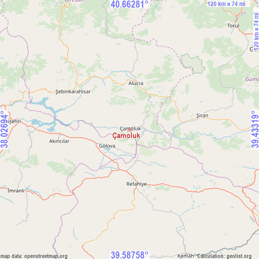
Çamoluk GPS coordinates[2]
40° 7' 38.352" North, 38° 43' 48.216" East
| Map corner | latitude | longitude |
|---|---|---|
| Upper-left | 40.66281°, | 38.02694° |
| Center: | 40.12732°, | 38.73006° |
| Lower-right: | 39.58758°, | 39.43319° |
| Map W x H: | 119.6×119.6 km | = 74.3×74.3mi |
| max Lat: | 42.02683° ⇑28.7% North |
| Çamoluk: | 40.12732° |
| min Lat: | ⇓71.3% South 35.9025° |
| min Long | Çamoluk | max Long |
| 25.90902° | 38.73006° | 44.60099° |
| W 65.3%⇐ | ⇒34.7% E |
Elevation
Elevation of Çamoluk is 1188 m = 3898 ft, and this is 470.6 m = 1544 ft above average elevation for this country.
| Max E: |
2682 m = 8799 ft | 20.2% |
| Çamoluk | 1188 m 3898 ft | |
| Avg. | 717.4 m = 2354 ft | |
Min E: |
0 m = 0 ft | 79.8% |
See also: Turkey elevation on elevation.city.
Geographical zone
Çamoluk is located in North temperate zone (between Tropic of Cancer and the Arctic Circle). Distance of this Northern Tropic circle is 1855.8 km =1153.1 mi to South.| Distance of | km | miles | from Çamoluk |
|---|---|---|---|
| North Pole | 5545.3 | 3445.7 | to North |
| Arctic Circle | 2939.4 | 1826.5 | to North |
| Tropic Cancer | 1855.8 | 1153.1 | to South |
| Equator | 4461.7 | 2772.4 | to South |


Nearby cities:
15 places around Çamoluk: (largest is in red/bold)
• Akarsu
24.2 km =15 mi,  204°
204°
• Akıncılar
33.5 km =20.8 mi,  259°
259°
• Alucra
21.1 km =13.1 mi,  5°
5°
• Bozoğlak
56.4 km =35 mi,  173°
173°
• Cengerli
38.4 km =23.9 mi,  164°
164°
• Doğanbeyli
54.6 km =33.9 mi,  151°
151°
• Evren
40 km =24.9 mi,  70°
70°
• Gökçekent
54.9 km =34.1 mi,  288°
288°
• Gölova
12.8 km =8 mi,  235°
235°
• Gümüşakar
37.4 km =23.2 mi,  187°
187°
• Refahiye
26.2 km =16.3 mi, 173°
• Suşehri
55 km =34.2 mi,  273°
273°
• Çatalçam
19.7 km =12.2 mi, 149°
• Şebin Karahisar
31.6 km =19.6 mi,  304°
304°
• Şiran
33.7 km =20.9 mi,  77°
77°
Sources, notices
• [Note1] Compared only with cities in Turkey existing in our database
• [Src1] Map data: © OpenStreetMap contributors (CC-BY-SA)
• [Src2] Other city data from geonames.org with taken over terms of usage.
• [Src3] Geographical zone / Annual Mean Temperature by Robert A. Rohde @ Wikipedia
