Şebin Karahisar geodata
Şebin Karahisar (Giresun) is a seat of a second-order administrative division; located in Turkey in Europe/Istanbul (GMT+3) time zone. With population of 47,360 people, there are 182 cities with bigger population in this country. Compared to other cities in Turkey, 74.3% of cities are located further ↓South; 63.8% of cities are located further ←West and 87.2% of cities have lower elevation than Şebin Karahisar. Note1


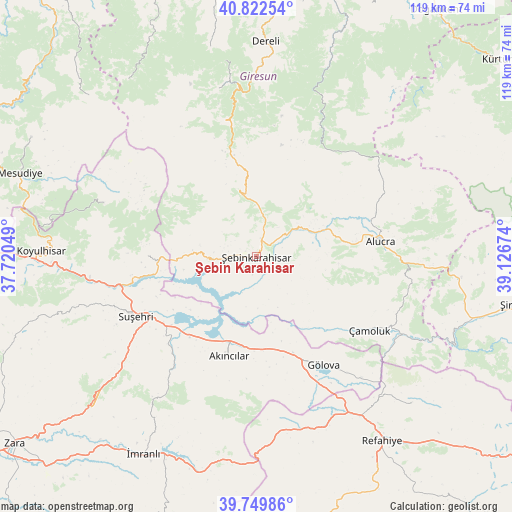
Şebin Karahisar GPS coordinates[2]
40° 17' 17.988" North, 38° 25' 24.996" East
| Map corner | latitude | longitude |
|---|---|---|
| Upper-left | 40.82254°, | 37.72049° |
| Center: | 40.28833°, | 38.42361° |
| Lower-right: | 39.74986°, | 39.12674° |
| Map W x H: | 119.3×119.3 km | = 74.1×74.1mi |
| max Lat: | 42.02683° ⇑25.7% North |
| Şebin Karahisar: | 40.28833° |
| min Lat: | ⇓74.3% South 35.9025° |
| min Long | Şebin Karahisa | max Long |
| 25.90902° | 38.42361° | 44.60099° |
| W 63.8%⇐ | ⇒36.2% E |
Elevation
Elevation of Şebin Karahisar is 1373 m = 4505 ft, and this is 655.6 m = 2151 ft above average elevation for this country.
| Max E: |
2682 m = 8799 ft | 12.8% |
| Şebin Karahisar | 1373 m 4505 ft | |
| Avg. | 717.4 m = 2354 ft | |
Min E: |
0 m = 0 ft | 87.2% |
See also: Şebin Karahisar elevation on elevation.city.
Geographical zone
Şebin Karahisar is located in North temperate zone (between Tropic of Cancer and the Arctic Circle). Distance of this Northern Tropic circle is 1873.7 km =1164.3 mi to South.| Distance of | km | miles | from Şebin Karahisar |
|---|---|---|---|
| North Pole | 5527.4 | 3434.6 | to North |
| Arctic Circle | 2921.5 | 1815.3 | to North |
| Tropic Cancer | 1873.7 | 1164.3 | to South |
| Equator | 4479.6 | 2783.5 | to South |


Nearby cities:
15 places around Şebin Karahisar: (largest is in red/bold)
• Akarsu
43.1 km =26.8 mi,  157°
157°
• Aksu
39.7 km =24.7 mi,  236°
236°
• Akıncılar
25 km =15.5 mi,  195°
195°
• Alucra
28.1 km =17.5 mi,  83°
83°
• Dereli
50.1 km =31.1 mi,  1°
1°
• Gökçekent
25.9 km =16.1 mi,  269°
269°
• Gölova
29.6 km =18.4 mi,  148°
148°
• Koyulhisar
50.9 km =31.6 mi, 271°
• Ortakent
36.9 km =22.9 mi,  288°
288°
• Refahiye
52.7 km =32.7 mi, 146°
• Suşehri
32.2 km =20 mi, 243°
• Yavuzkemal
45.6 km =28.3 mi,  350°
350°
• Çamoluk
31.6 km =19.6 mi,  124°
124°
• Çatalçam
50.2 km =31.2 mi,  134°
134°
• İmranlı
52.9 km =32.9 mi,  209°
209°
Sources, notices
• [Note1] Compared only with cities in Turkey existing in our database
• [Src1] Map data: © OpenStreetMap contributors (CC-BY-SA)
• [Src2] Other city data from geonames.org with taken over terms of usage.
• [Src3] Geographical zone / Annual Mean Temperature by Robert A. Rohde @ Wikipedia
