Akıncılar geodata
Akıncılar (Sivas) is a seat of a second-order administrative division; located in Turkey in Europe/Istanbul (GMT+3) time zone. With population of 4,779 people, there are 741 cities with bigger population in this country. Compared to other cities in Turkey, 70.4% of cities are located further ↓South; 63.3% of cities are located further ←West and 82.2% of cities have lower elevation than Akıncılar. Note1


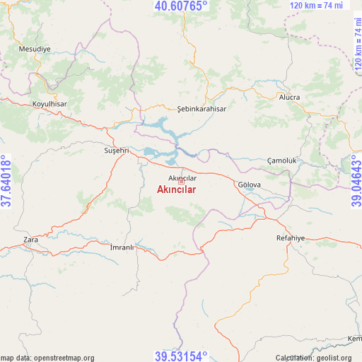
Akıncılar GPS coordinates[2]
40° 4' 18.192" North, 38° 20' 35.88" East
| Map corner | latitude | longitude |
|---|---|---|
| Upper-left | 40.60765°, | 37.64018° |
| Center: | 40.07172°, | 38.3433° |
| Lower-right: | 39.53154°, | 39.04643° |
| Map W x H: | 119.7×119.7 km | = 74.4×74.4mi |
| max Lat: | 42.02683° ⇑29.6% North |
| Akıncılar: | 40.07172° |
| min Lat: | ⇓70.4% South 35.9025° |
| min Long | Akıncılar | max Long |
| 25.90902° | 38.3433° | 44.60099° |
| W 63.3%⇐ | ⇒36.7% E |
Elevation
Elevation of Akıncılar is 1240 m = 4068 ft, and this is 522.6 m = 1715 ft above average elevation for this country.
| Max E: |
2682 m = 8799 ft | 17.8% |
| Akıncılar | 1240 m 4068 ft | |
| Avg. | 717.4 m = 2354 ft | |
Min E: |
0 m = 0 ft | 82.2% |
See also: Turkey elevation on elevation.city.
Geographical zone
Akıncılar is located in North temperate zone (between Tropic of Cancer and the Arctic Circle). Distance of this Northern Tropic circle is 1849.6 km =1149.3 mi to South.| Distance of | km | miles | from Akıncılar |
|---|---|---|---|
| North Pole | 5551.5 | 3449.5 | to North |
| Arctic Circle | 2945.6 | 1830.3 | to North |
| Tropic Cancer | 1849.6 | 1149.3 | to South |
| Equator | 4455.6 | 2768.6 | to South |


Nearby cities:
15 places around Akıncılar: (largest is in red/bold)
• Akarsu
28 km =17.4 mi,  124°
124°
• Aksu
26.3 km =16.3 mi,  274°
274°
• Alucra
44.2 km =27.5 mi,  51°
51°
• Gökçekent
30.6 km =19 mi,  321°
321°
• Gölova
22.4 km =13.9 mi,  92°
92°
• Gümüşakar
41.8 km =26 mi,  137°
137°
• Karacaören
42.6 km =26.5 mi,  207°
207°
• Kuruçay
49.3 km =30.6 mi,  166°
166°
• Ortakent
45.6 km =28.3 mi, 321°
• Refahiye
41.1 km =25.5 mi, 118°
• Suşehri
24.1 km =15 mi,  294°
294°
• Çamoluk
33.5 km =20.8 mi,  79°
79°
• Çatalçam
44.3 km =27.5 mi,  104°
104°
• İmranlı
29.3 km =18.2 mi,  221°
221°
• Şebin Karahisar
25 km =15.5 mi,  15°
15°
Sources, notices
• [Note1] Compared only with cities in Turkey existing in our database
• [Src1] Map data: © OpenStreetMap contributors (CC-BY-SA)
• [Src2] Other city data from geonames.org with taken over terms of usage.
• [Src3] Geographical zone / Annual Mean Temperature by Robert A. Rohde @ Wikipedia
