Yedigöz geodata
Yedigöz (Kilis) is a populated place; located in Turkey in Europe/Istanbul (GMT+3) time zone. With population of 541 people, there are 1286 cities with bigger population in this country. Compared to other cities in Turkey, 91.5% of cities are located further ↑North; 56.3% of cities are located further ←West and 54.1% of cities have lower elevation than Yedigöz. Note1


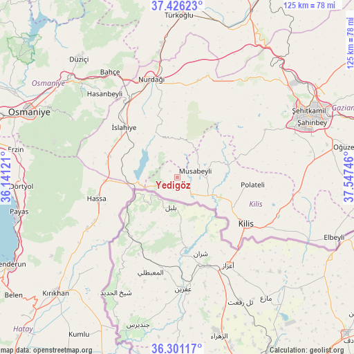
Yedigöz GPS coordinates[2]
36° 51' 56.772" North, 36° 50' 39.588" East
| Map corner | latitude | longitude |
|---|---|---|
| Upper-left | 37.42623°, | 36.14121° |
| Center: | 36.86577°, | 36.84433° |
| Lower-right: | 36.30117°, | 37.54746° |
| Map W x H: | 125.1×125.1 km | = 77.7×77.7mi |
| max Lat: | 42.02683° ⇑91.5% North |
| Yedigöz: | 36.86577° |
| min Lat: | ⇓8.5% South 35.9025° |
| min Long | Yedigöz | max Long |
| 25.90902° | 36.84433° | 44.60099° |
| W 56.3%⇐ | ⇒43.7% E |
Elevation
Elevation of Yedigöz is 776 m = 2546 ft, and this is 58.6 m = 192 ft above average elevation for this country.
| Max E: |
2682 m = 8799 ft | 45.9% |
| Yedigöz | 776 m 2546 ft | |
| Avg. | 717.4 m = 2354 ft | |
Min E: |
0 m = 0 ft | 54.1% |
See also: Turkey elevation on elevation.city.
Geographical zone
Yedigöz is located in North temperate zone (between Tropic of Cancer and the Arctic Circle). Distance of this Northern Tropic circle is 1493.2 km =927.8 mi to South.| Distance of | km | miles | from Yedigöz |
|---|---|---|---|
| North Pole | 5908 | 3671.1 | to North |
| Arctic Circle | 3302.1 | 2051.8 | to North |
| Tropic Cancer | 1493.2 | 927.8 | to South |
| Equator | 4099.1 | 2547.1 | to South |


Nearby cities:
15 places around Yedigöz: (largest is in red/bold)
• Aktepe
36.8 km =22.9 mi,  240°
240°
• Aşağı Karafakılı
27.3 km =17 mi,  249°
249°
• Burç
34 km =21.1 mi,  61°
61°
• Demirkonak
42.3 km =26.3 mi,  221°
221°
• Fevzipaşa
31.4 km =19.5 mi,  324°
324°
• Güldüzü
24.2 km =15 mi,  89°
89°
• Hasanbeyli
39.4 km =24.5 mi, 317°
• Hassa
30 km =18.6 mi,  255°
255°
• Kilis
29.3 km =18.2 mi,  124°
124°
• Musabeyli
7 km =4.3 mi,  70°
70°
• Nurdağı
35 km =21.7 mi,  344°
344°
• Polateli
26.8 km =16.7 mi,  95°
95°
• Sakçagöz
34.6 km =21.5 mi,  10°
10°
• Yarpuz
42 km =26.1 mi,  298°
298°
• İslahiye
26 km =16.2 mi,  312°
312°
Sources, notices
• [Note1] Compared only with cities in Turkey existing in our database
• [Src1] Map data: © OpenStreetMap contributors (CC-BY-SA)
• [Src2] Other city data from geonames.org with taken over terms of usage.
• [Src3] Geographical zone / Annual Mean Temperature by Robert A. Rohde @ Wikipedia
