Musabeyli geodata
Musabeyli (Kilis) is a seat of a second-order administrative division; located in Turkey in Europe/Istanbul (GMT+3) time zone. With population of 1,938 people, there are 966 cities with bigger population in this country. Compared to other cities in Turkey, 91% of cities are located further ↑North; 56.5% of cities are located further ←West and 53.1% of cities have lower elevation than Musabeyli. Note1


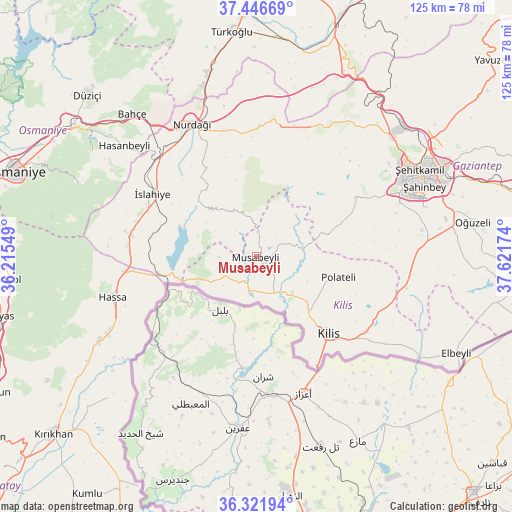
Musabeyli GPS coordinates[2]
36° 53' 11.004" North, 36° 55' 6.996" East
| Map corner | latitude | longitude |
|---|---|---|
| Upper-left | 37.44669°, | 36.21549° |
| Center: | 36.88639°, | 36.91861° |
| Lower-right: | 36.32194°, | 37.62174° |
| Map W x H: | 125.1×125.1 km | = 77.7×77.7mi |
| max Lat: | 42.02683° ⇑91% North |
| Musabeyli: | 36.88639° |
| min Lat: | ⇓9% South 35.9025° |
| min Long | Musabeyli | max Long |
| 25.90902° | 36.91861° | 44.60099° |
| W 56.5%⇐ | ⇒43.5% E |
Elevation
Elevation of Musabeyli is 756 m = 2480 ft, and this is 38.6 m = 127 ft above average elevation for this country.
| Max E: |
2682 m = 8799 ft | 46.9% |
| Musabeyli | 756 m 2480 ft | |
| Avg. | 717.4 m = 2354 ft | |
Min E: |
0 m = 0 ft | 53.1% |
See also: Turkey elevation on elevation.city.
Geographical zone
Musabeyli is located in North temperate zone (between Tropic of Cancer and the Arctic Circle). Distance of this Northern Tropic circle is 1495.5 km =929.3 mi to South.| Distance of | km | miles | from Musabeyli |
|---|---|---|---|
| North Pole | 5905.7 | 3669.6 | to North |
| Arctic Circle | 3299.8 | 2050.4 | to North |
| Tropic Cancer | 1495.5 | 929.3 | to South |
| Equator | 4101.4 | 2548.5 | to South |


Nearby cities:
15 places around Musabeyli: (largest is in red/bold)
• Aktepe
43.7 km =27.2 mi,  241°
241°
• Aşağı Karafakılı
34.3 km =21.3 mi,  249°
249°
• Burç
27.1 km =16.8 mi,  58°
58°
• Fevzipaşa
34 km =21.1 mi,  312°
312°
• Güldüzü
17.7 km =11 mi,  96°
96°
• Hasanbeyli
42.6 km =26.5 mi, 309°
• Hassa
37 km =23 mi, 254°
• Kilis
25.8 km =16 mi,  137°
137°
• Nurdağı
35.3 km =21.9 mi,  332°
332°
• Polateli
20.7 km =12.9 mi, 104°
• Sakçagöz
31.7 km =19.7 mi,  359°
359°
• Yedigöz
7 km =4.3 mi, 250°
• Zeytinli
45.4 km =28.2 mi,  80°
80°
• İslahiye
29.9 km =18.6 mi,  301°
301°
• Şahinbey
41.8 km =26 mi, 64°
Sources, notices
• [Note1] Compared only with cities in Turkey existing in our database
• [Src1] Map data: © OpenStreetMap contributors (CC-BY-SA)
• [Src2] Other city data from geonames.org with taken over terms of usage.
• [Src3] Geographical zone / Annual Mean Temperature by Robert A. Rohde @ Wikipedia
