Burç geodata
Burç (Gaziantep) is a seat of a third-order administrative division; located in Turkey in Europe/Istanbul (GMT+3) time zone. In our database, there are 1323 cities with bigger population. Compared to other cities in Turkey, 87.7% of cities are located further ↑North; 57.4% of cities are located further ←West and 61.7% of cities have lower elevation than Burç. Note1


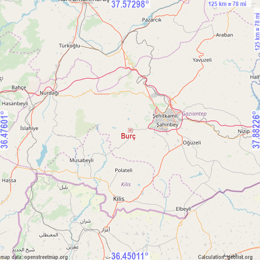
Burç GPS coordinates[2]
37° 0' 49.032" North, 37° 10' 44.868" East
| Map corner | latitude | longitude |
|---|---|---|
| Upper-left | 37.57298°, | 36.47601° |
| Center: | 37.01362°, | 37.17913° |
| Lower-right: | 36.45011°, | 37.88226° |
| Map W x H: | 124.9×124.9 km | = 77.6×77.6mi |
| max Lat: | 42.02683° ⇑87.7% North |
| Burç: | 37.01362° |
| min Lat: | ⇓12.3% South 35.9025° |
| min Long | Burç | max Long |
| 25.90902° | 37.17913° | 44.60099° |
| W 57.4%⇐ | ⇒42.6% E |
Elevation
Elevation of Burç is 909 m = 2982 ft, and this is 191.6 m = 629 ft above average elevation for this country.
| Max E: |
2682 m = 8799 ft | 38.3% |
| Burç | 909 m 2982 ft | |
| Avg. | 717.4 m = 2354 ft | |
Min E: |
0 m = 0 ft | 61.7% |
See also: Turkey elevation on elevation.city.
Geographical zone
Burç is located in North temperate zone (between Tropic of Cancer and the Arctic Circle). Distance of this Northern Tropic circle is 1509.6 km =938 mi to South.| Distance of | km | miles | from Burç |
|---|---|---|---|
| North Pole | 5891.5 | 3660.8 | to North |
| Arctic Circle | 3285.6 | 2041.6 | to North |
| Tropic Cancer | 1509.6 | 938 | to South |
| Equator | 4115.5 | 2557.3 | to South |


Nearby cities:
15 places around Burç: (largest is in red/bold)
• Gaziantep
18.8 km =11.7 mi,  74°
74°
• Güldüzü
17.2 km =10.7 mi,  198°
198°
• Gündoğan
36.1 km =22.4 mi,  114°
114°
• Kilis
33.6 km =20.9 mi,  189°
189°
• Musabeyli
27.1 km =16.8 mi,  238°
238°
• Narlı
42.2 km =26.2 mi,  354°
354°
• Oğuzeli
30.2 km =18.8 mi,  100°
100°
• Polateli
19.4 km =12.1 mi, 189°
• Sakçagöz
29.2 km =18.1 mi,  306°
306°
• Yakacık
34.8 km =21.6 mi, 112°
• Yedigöz
34 km =21.1 mi, 241°
• Yeşildere
28.4 km =17.6 mi, 99°
• Zeytinli
22.7 km =14.1 mi, 107°
• Şahinbey
15.1 km =9.4 mi,  75°
75°
• Şehitkamil
19.3 km =12 mi, 67°
Sources, notices
• [Note1] Compared only with cities in Turkey existing in our database
• [Src1] Map data: © OpenStreetMap contributors (CC-BY-SA)
• [Src2] Other city data from geonames.org with taken over terms of usage.
• [Src3] Geographical zone / Annual Mean Temperature by Robert A. Rohde @ Wikipedia
