Denizciler geodata
Denizciler (Hatay) is a populated place; located in Turkey in Europe/Istanbul (GMT+3) time zone. With population of 17,495 people, there are 356 cities with bigger population in this country. Compared to other cities in Turkey, 95.9% of cities are located further ↑North; 52.5% of cities are located further ←West and 89.7% of cities have higher elevation than Denizciler. Note1


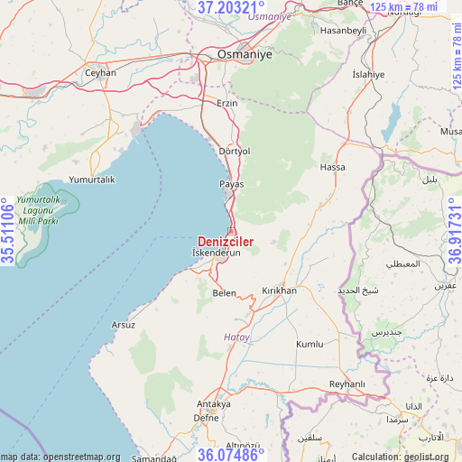
Denizciler GPS coordinates[2]
36° 38' 27.96" North, 36° 12' 51.048" East
| Map corner | latitude | longitude |
|---|---|---|
| Upper-left | 37.20321°, | 35.51106° |
| Center: | 36.6411°, | 36.21418° |
| Lower-right: | 36.07486°, | 36.91731° |
| Map W x H: | 125.5×125.5 km | = 78×78mi |
| max Lat: | 42.02683° ⇑95.9% North |
| Denizciler: | 36.6411° |
| min Lat: | ⇓4.1% South 35.9025° |
| min Long | Denizciler | max Long |
| 25.90902° | 36.21418° | 44.60099° |
| W 52.5%⇐ | ⇒47.5% E |
Elevation
Elevation of Denizciler is 41 m = 135 ft, and this is 676.4 m = 2219 ft below average elevation for this country.
| Max E: |
2682 m = 8799 ft | 89.7% |
| Avg. | 717.4 m = 2354 ft | |
| Denizciler | 41 m = 135 ft | |
Min E: |
0 m = 0 ft | 10.3% |
See also: Turkey elevation on elevation.city.
Geographical zone
Denizciler is located in North temperate zone (between Tropic of Cancer and the Arctic Circle). Distance of this Northern Tropic circle is 1468.2 km =912.3 mi to South.| Distance of | km | miles | from Denizciler |
|---|---|---|---|
| North Pole | 5933 | 3686.6 | to North |
| Arctic Circle | 3327.1 | 2067.4 | to North |
| Tropic Cancer | 1468.2 | 912.3 | to South |
| Equator | 4074.1 | 2531.5 | to South |


Nearby cities:
15 places around Denizciler: (largest is in red/bold)
• Aktepe
25.1 km =15.6 mi,  74°
74°
• Aşağı Karafakılı
34.2 km =21.3 mi,  63°
63°
• Balarmudu
17.3 km =10.7 mi,  88°
88°
• Belen
17 km =10.6 mi,  185°
185°
• Demirkonak
28.7 km =17.8 mi,  103°
103°
• Dörtyol
22.1 km =13.7 mi,  3°
3°
• Gyuvench
19.3 km =12 mi,  75°
75°
• Hassa
32.3 km =20.1 mi, 56°
• Konaklı
19.4 km =12.1 mi,  19°
19°
• Kırıkhan
20.3 km =12.6 mi,  140°
140°
• Payas
12.8 km =8 mi, 0°
• Serinyol
31.1 km =19.3 mi,  180°
180°
• Yalangöz
27.2 km =16.9 mi,  105°
105°
• Çırtıman
13.2 km =8.2 mi, 192°
• İskenderun
7 km =4.3 mi,  211°
211°
Sources, notices
• [Note1] Compared only with cities in Turkey existing in our database
• [Src1] Map data: © OpenStreetMap contributors (CC-BY-SA)
• [Src2] Other city data from geonames.org with taken over terms of usage.
• [Src3] Geographical zone / Annual Mean Temperature by Robert A. Rohde @ Wikipedia
