Boztepe geodata
Boztepe (Tokat) is a seat of a third-order administrative division; located in Turkey in Europe/Istanbul (GMT+3) time zone. In our database, there are 1323 cities with bigger population. Compared to other cities in Turkey, 72.3% of cities are located further ↓South; 50.4% of cities are located further →East and 54.3% of cities have lower elevation than Boztepe. Note1


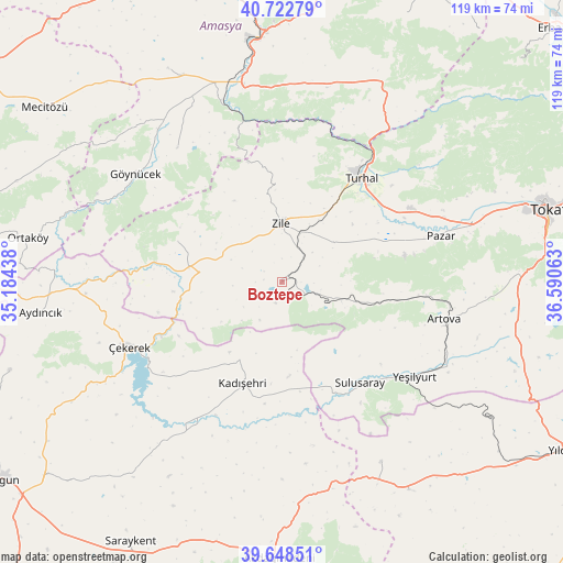
Boztepe GPS coordinates[2]
40° 11' 16.008" North, 35° 53' 15" East
| Map corner | latitude | longitude |
|---|---|---|
| Upper-left | 40.72279°, | 35.18438° |
| Center: | 40.18778°, | 35.8875° |
| Lower-right: | 39.64851°, | 36.59063° |
| Map W x H: | 119.4×119.4 km | = 74.2×74.2mi |
| max Lat: | 42.02683° ⇑27.7% North |
| Boztepe: | 40.18778° |
| min Lat: | ⇓72.3% South 35.9025° |
| min Long | Boztepe | max Long |
| 25.90902° | 35.8875° | 44.60099° |
| W 49.6%⇐ | ⇒50.4% E |
Elevation
Elevation of Boztepe is 782 m = 2566 ft, and this is 64.6 m = 212 ft above average elevation for this country.
| Max E: |
2682 m = 8799 ft | 45.7% |
| Boztepe | 782 m 2566 ft | |
| Avg. | 717.4 m = 2354 ft | |
Min E: |
0 m = 0 ft | 54.3% |
See also: Turkey elevation on elevation.city.
Geographical zone
Boztepe is located in North temperate zone (between Tropic of Cancer and the Arctic Circle). Distance of this Northern Tropic circle is 1862.5 km =1157.3 mi to South.| Distance of | km | miles | from Boztepe |
|---|---|---|---|
| North Pole | 5538.6 | 3441.5 | to North |
| Arctic Circle | 2932.7 | 1822.3 | to North |
| Tropic Cancer | 1862.5 | 1157.3 | to South |
| Equator | 4468.5 | 2776.6 | to South |


Nearby cities:
15 places around Boztepe: (largest is in red/bold)
• Artova
36 km =22.4 mi,  102°
102°
• Dökmetepe
37 km =23 mi,  68°
68°
• Ezinepazarı
47.5 km =29.5 mi,  26°
26°
• Gediksaray
36.2 km =22.5 mi,  322°
322°
• Göynücek
38.7 km =24 mi,  307°
307°
• Kadışehri
22.9 km =14.2 mi,  200°
200°
• Pazar
35 km =21.7 mi, 73°
• Sulusaray
27.3 km =17 mi,  142°
142°
• Turhal
27.6 km =17.1 mi,  36°
36°
• Yeşilyurt
34.8 km =21.6 mi,  125°
125°
• Yeşilyurt
42.3 km =26.3 mi, 68°
• Zile
12.8 km =8 mi,  359°
359°
• Çamlıbel
51.4 km =31.9 mi, 102°
• Çekerek
35.7 km =22.2 mi,  249°
249°
• İğdir
23.8 km =14.8 mi,  291°
291°
Sources, notices
• [Note1] Compared only with cities in Turkey existing in our database
• [Src1] Map data: © OpenStreetMap contributors (CC-BY-SA)
• [Src2] Other city data from geonames.org with taken over terms of usage.
• [Src3] Geographical zone / Annual Mean Temperature by Robert A. Rohde @ Wikipedia
